What Pennsylvania rail trails allow horses?
This page can help you quickly determine Pennsylvania’s Rail Trails that allow horse riding. It’s often a real PITA trying to find the information buried on trail websites, and sometimes they can’t even be bothered to include it.
This page has a list of major trails below as well as an online map.
There are plenty of other options for horseback riding, such as state and national parks, and some state game lands allow equestrians (during non-hunting times). Rail trails have the advantage of being easy, well maintained, and generally open year round.
This page is not an exhaustive list. It will be updated as I look into new locations.
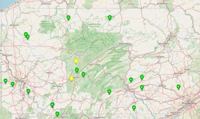
Online Map
We have created an online map using Mapbox that shows significant rail trails in Pennsylvania that allow horse riding. Eventually maybe we can make our trail descriptions below pop up in the map… but that’s another project.
Mapbox – Pennsylvania Rail Trails ![]()
Notes:
Green trails are recommended. Yellow trails may not be as horse friendly or well maintained.
Markers are at main trail access point or the approximate middle point if multiple trailheads.
If you click on a marker it should show you the trail name, but they aren’t hotlinked. Yet.
Other online info
The Rails to Trails website will list trails for horse use, but the info given is poor. Many trails are listed as if they allow horses on their entirety when they only allow them on a tiny segment. Many trails are so short they aren’t even worth bothering with! And any detailed info on horse use is buried in the descriptions for the trails and hard to find. The site is great overall, but very poor at providing userful info for horse users!
Horses and Horseback Riding Permitted
The following Pennsylvania rail trails allow full or partial horse riding access. Please support them by making a donation or joining their support group.

 Great Allegheny Passage (GAP Trail)
Horses are only permitted on three sections of this 150 mile trail, two of which are pretty short. They are listed west to east…
| Section | Notes | Distance | Map |
|---|---|---|---|
| Boston PA (east of McKeesport) to Connellsville PA | Not the most exciting section of the trail, few bridges. | 39 miles | map link |
| Rockwood PA to Garrett PA | Segment ends west of Salisbury viaduct | about 7.3 miles | map link |
| Frostburg MD to PA border | Includes Borden tunnel but ends short of Big Savage tunnel. Parking at Frostburg seems tight for a horse trailer. | about 5 miles | map link |
Regretfully, riding sections do not include nearby major attractions of the trail, massive Salisbury viaduct and Big Savage Tunnel. The Frostburg section does pass through Borden Tunnel, which is about 1000 feet long and has lighting on motion sensors.
Whether my horse would actually go across Salisbury viaduct is another issue, but still… Personally, I’d be tempted to ride at least to the amazing overlook at the east end of Big Savage tunnel.
Info at TrailLink: GAP Trail ![]()
Lower Trail
Horseback riding is permitted on the entire 16.5 mile length! Please ride only the grass berms wherever possible.
In 2022 the trail connected to adjacent Canoe Creek State Park. Planning has begun on an extension into Hollidaysburg. We hope this happens soon!
See our Lower Trail Riding Guide or visit TrailLink: Lower Trail ![]()
Cumberland Valley Rail Trail
We are happy to see that this 13.7 mile (and growing!) trail permits horseback use over its entire length. It currently reaches from Shippensburg to Newville, and is planned (2024) to extend into Carlisle.
View info at TrailLink: Cumberland Valley Trail ![]()
Lebanon Valley Rail Trail
In 2022 the trail permitted an electric utility to pave a section north of Cornwall which has likely cut into the area permitting horses. The exact northern limit of riding is unclear, as they can’t be bothered to update their website. You should probably assume horses are no longer allowed north of Cornwall borough.
Here is a GraphHopper map trimmed to Rocherty Road ![]() (the old northern limit for horses).
(the old northern limit for horses).
View general trail info at TrailLink: Lebanon Valley Rail Trail ![]()
I’m not clear why this trail still goes by two names, with it Conewago Recreation Trail (in Lancaster county). It should just be treated as one trail because users sure don’t care what county they are in. Get it together, folks!
Lykens Valley Rail Trail
This trail extends east of the Susquehanna river, parallel to PA 209 from Millerstown to Williamstown. Three segments which total 9 miles have been constructed, out of 20 miles planned.
Thankfully, the trail does allow horseback riding. Parts of the six miles between Lykens and Williamstown are wooded and run through State Game Lands, and are probably most suitable to equestrian use.
Swatara Rail Trail
This 10 mile trail is supposed to be really nice and offers horseback riding on its entire length. There is apparently a way to turn at least part of it into a loop using an abandoned section of road known as Bear Hole Trail. PA Equine Council also has constructed a connecting horse trail of a couple miles outside Suedburg (though we’ve never found ANY info other than it’s name on a map!).
Eventually Swatara trail may connect with Lebanon Valley trail (above), which would be immensely cool; unfortunately the connecting section will almost certainly not accommodate horses.
I’m itching to take our first ride across a lenticular truss bridge while visiting the Swatara Trail 🙂
Read more at TrailLink: Swatara Trail ![]()
York County Heritage Rail Trail
One of the original “big” trails at 27+ miles, this trails extends all the way from the city of York to the Mason-Dixon line, where it continues as the Northern Central Railroad Trail in Maryland (now renamed for someone nobody has ever heard of). Thankfully both trails allow horses, though you probably want to avoid the urban section at the north end in the city of York, most of which I believe is now asphalted. There is a short tunnel on the York county section.
Notice that there is an operating steam train at New Freedom near the southern end. Train runs on tracks immediately adjacent to the trail, which might allow for some interesting desensitization opportunities! Or instant death 🙂
Details at TrailLink: York county ![]()
Panhandle Trail
According to the trail website, this trail allows horses along its entire length. We suppose this is still true, even though most of it is now apparently paved. We’ve been unable to determine whether horses are allowed on the segment in West Virginia, but that still gives 25 miles of trail which are open. As usual, you are asked to avoid surfaced areas and ride on grass or gravel shoulders wherever possible.
The western end is described as a climb through hardwood forests, which sounds ideal. The eastern end enters the suburbs of Pittsburgh, so it’s probably a little less-suited to equestrian users. It does sound like there are several towns where you may be able to access food and drink along or close to the trail.
The most likely parking we’ve spotted is on Harmon Creek Road in Colliers WV, just a stone’s throw from the WV/PA border. State Game Lands 117 in Burgettstown PA has an area where it looks like you could park and ride to the trail. Curiously it is also on Harmon Creek Road, but a different one!
Helicon Brewing in Oakdale fronts on the trail, hosts food trucks, and appears to have a lawn. That sounds like a necessary stop. I wonder if they have a mounting block!
Pine Creek Rail Trail
This trail passes through the “Grand Canyon of Pennsylvania” aka Pine Creek Gorge. The trail is 62 miles long, but there is one problem… horses are only permitted on 5.5 miles of it! Extremely disappointing. Since Pine Creek isn’t near anything, this seems like a lot of travel for a short ride. If you’re already headed there and have some horses in your trunk it might be fun to ride, but it seems silly to make a special trip.
The open section runs from the Ansonia parking area (north end) to the Tiadaghton campground (south end).
Info at Pine Creek Rail Trail horseback riding ![]()
Bells Gap Rail Trail
This 6 mile trail operated by the Lower Trail group is open to horseback use over its entire length. About 2.1 miles is well surfaced with crushed limestone. The rest is rough stone and grass through State Game Lands. Bells Gap is not as quiet or well developed as Lower Trail, but it’s still worth a visit.
There is a nice parking area at the start with space for a couple trailers, a port-a-pot, and a small pavilion. There is some grazing and shade. A nearby house has several hounds outside, and a shooting club nearby provided a good bit of noise at the start, but you leave these behind pretty quickly. There is intermittent traffic noise from the adjacent road, but it’s not mostly not bad. Cows and two mini donkeys in nearby fields may watch you head up the trail.
There are many benches and some picnic tables along the trail. At the end of the developed trail there is an overlook with a grassy area and a covered table where you could take a break, but remounting is for you to figure out!
A compelling time to visit is fall hunting season: the first 2.1 miles of trail do not pass through State Game Lands and have good southern exposure, making best use of limited fall sunlight. The first mile or so is somewhat sheltered from wind, but as you get up the trail exposure does increase. In the summer the trail should be mostly shaded, and leaves will cut down on the traffic noise.
Unlike most rail trails, this is a steady 3-4% climb from the parking lot, so a 4.2 mile round trip is a decent workout.
We recommend Houser’s Subs just down the road for lunch. They have Richey’s ice cream, so stop on your way home as well!
Be cautious pulling out onto 865 when you leave. Visibility is poor and traffic sometimes goes too fast.
Info at TrailLink: Bells Gap ![]()
Houtzdale Line Trail
This trail claims 8 miles from Houtzdale southwest to Smoke Run. It’s a shame that it’s not kept in better shape. Surface is a bit rough, facilities are minimal. Houtzdale and the east end are pretty ugly and not really worth riding.
If you want to ride horses there, we suggest starting at the southwest end at Smoke Run, where there is a decent-sized parking lot with some grazing. The first few miles to Ramey pass mostly through woods and are fairly scenic and peaceful. You can also go about a mile to the west of the parking lot before you reach a bridge which is blocked; this section is rough railroad ballast (stone).
While there are state game lands near Smoke Run, they don’t directly border the trail, so this may be a reasonable place to ride during hunting seasons (wearing fluorescent orange of course!).
There may be a portable toilet at Smoke Run in the summer but in the off-season there are no facilities on the trail. Houtzdale does have convenience stores with fuel and some restaurants. Houtzdale does not have obvious trail parking.
Knox & Kane Trail
7.8 miles are open for equestrian use, between Route 219 at Mount Jewett and Kinzua Bridge State Park. But horse trailers are NOT allowed to park at the bridge park!
The trail group for this section developed an equestrian parking area where you can park trailers in a grass field near the state park. There is a nearby picnic area. There are signs for trailer parking on Lindholm Road west of the bridge park.
Equestrian parking location:
- north side of Lindholm Rd
- about midway between Mt Jewett borough boundary and the state park
- approximate coordinates 41.74106, -78.60085

- this is a grass field so use caution after wet weather
On weekends you can also park adjacent to the trail behind the Mount Jewett borough building (just off of US 6 on Center St). Parking is limited and please clean up after your horse!
The K&K trail has the potential to reach 70+ miles through some remote areas. Hopefully additional areas will be opened to horses. Joining and supporting the trail organization might be a way to help that happen.
Montour Trail
Montour Trail around the west side of Pittsburgh is an amazing rail trail, which appears to have come a long way since I last biked it (quite a few years back), with many new bridges now open. Unfortunately, only a small section of its 60+ miles is open to horse use, but at least it is something.
According to TrailLink, the open section is far southwest of downtown Pittsburgh, in the area between McDonald and Canonsburg. It runs from the intersection of routes 980 and 50 (Venice) running east to Morganza Road and the “Georgetown Road” parking area in Hendersonville. This is Cecil township of Washington county. Length appears to be 5 miles.
The parking lot at Hendersonville (east end) appears quite large, while the one at the west end is very small and probably not suitable for a trailer.
Graphhopper map of this section ![]()
My only grumble is that some of their rules are a bit ridiculous. Dismount and lead your horse across bridges?? Umm, maybe not when you’re riding a 16.3hh horse, unless they have benches every 100 feet!
Allegheny River + Justus Trail
These two trails combine to run 32 miles along the Allegheny River southwest of Oil City, through the historic town of Franklin, ending at Emlenton on I-80. The trail is paved with a gravel road adjacent for horses.
Features include a number of bridges and two LONG tunnels (probably unlit), as well as the Sandy Creek Trail, which crosses overhead on an impressive bridge (see below).
At the southeast end near Foxburg the trail gets sketchy (2024). Hopefully they can continue construction soon.
Sandy Creek Trail
This trail crosses the Allegheny River trail on the massive Belmar Bridge south of Franklin PA and runs 12 miles along the Allegheny River and East Sandy Creek. It includes a tunnel and 7 bridges.
It doesn’t seem like it’s improved as much as some trails, and parking at the west end seems sketchy. Otherwise it seems like it is well worth a visit!
New Portage Branch
While not really developed as a rail trail, part of this former-railroad route north of old route 22 at Muleshoe Curve belongs to State Game Lands 198 and and is a designated trail open to horse use at non-hunting times. SGL says it is 6.8 miles, though it is out and back.
It’s been a while since I visited, but I remember it being pretty rough, surfaced mostly with old railroad ballast. Near Muleshoe Curve is pretty nice. The far end gets close to new US 22 and is a bit noisy. Note that use is restricted at certain times of year: find more info at the DCNR SGL pages ![]()
Perkiomen Trail
This looks like a very nice trail, often mentioned in horse news. Based on the area it seems likely that it gets considerable horse use. There are connecting trails and a 10-site equestrian campground in adjacent Green Lane Park ![]() .
.
It extends from Audubon (almost Valley Forge) north to Green Lane Park, about 19 miles. Probably the north end from Schwenksville to Green Lane is most suitable to horse use, as the southern end is getting into pretty congested areas.
Surface is crushed stone with a few paved areas. Numerous trailheads exist, and water and restrooms appear to be readily available. Apparently several restaurants are along the trail. Possibly one of the most welcoming rail trails in the state for horses, due to its (wealthy, yet semi-rural) location in Montgomery county.
PWS Trail System
This nebulous network of snowmobile trails and forest roads in Forbes State Forest and several nearby parks theoretically allows horseback riding in some areas. Unfortunately it’s hard to even understand the components of the “trail system” but you might check into Forbes Forest and nearby parks.
Probably you are going to need to talk to someone in the Forestry office there to learn what’s really available. I’ve never found a state map that is very helpful.
Chester Valley Trail – Montgomery County segment
This trail starts by crossing the Schuylkill River in Norristown/Bridgeport (surburban Philadephia) and currently extends 5 miles through King of Prussia and Upper Merion. It is open to horse riding. The much longer section in Chester county, however, does not allow horses.
Kudos to Montgomery county for allowing horseback riders to use their trails! Too bad Chester county, which is home to a lot of horse owners, has to be a bunch of morons about multi-use trail access.
Schuylkill River Trail – Montgomery County segment
Somewhat surprisingly, the section of the Schuylkill River Trail in Montgomery county (suburban Philadelphia) is open to horse riding. This includes the towns of Whitemarsh, West Conshohocken, Upper Merion, Bridgeport, Valley Forge, Upper Providence. Total distance is nearly 20 miles and the trail includes some substantial bridges.
Please be aware that other sections of the Schuylkill River Trail (Chester county, Berks county) do not allow horseback riding.
Shenango Trail
This trail in Mercer county is listed as 7.5 miles and horses are supposed to be permitted. A bit of investigation suggested that a lot of it can be very wet as it’s along a former canal and towpaths. Some parts of it may involve boardwalks, which may not be passable with horses. But some reviews do mention seeing horses, so people do ride there. You may need to investigate what parts of it are really practical to use before making a special trip.
Smethport (Potato Creek Trails)
There is a network of trails just outside Smethport which includes a short section of former PRR railroad grade. Most of the trails in the network are open to horse use!
Stony Valley Rail Trail
This State Game Lands road on a former railroad grade is a designated horse route, meaning it can be used for riding outside of hunting days.
Length is about 18 miles but it’s out and back, and gated all but one day of the year. Surface is gravel and dirt. No facilities. Really only accessible from west end near Dauphin.
There are other trails in this area which we overlooked when mapping SGL trails into OpenStreetMap. You may want to look into these.
West Penn Trail
As best we can determine, limited sections of this trail near Saltsburg are open to horse use. Trail information is provided by multiple counties with horrible coordination and is very confusing.
Horses appear to be permitted on three connected sections which total about 7 miles in length:
- Dick Mayer Section (part of it) ~ 1 mile
- Saltsburg Section – 4 miles
- Kiski Section – 2 miles
Dick Mayer Section runs from a parking lot on Auen Road near Tunnelton west to Elders Run where it joins the Saltsburg Section.
Saltsburg Section runs west along the Conemaugh River from Elders Run to Saltsburg.
Kiski Section runs along the Kiski River, 2 miles north from Saltsburg to the current end of trail.
Clarion Highlands Trail
Supposedly the eastern 5 miles of the trail are open to horseback riding. It sounds like this is undeveloped trail, basically just overgrown railroad bed through state game lands 45. Parking may be challenging to find. If anyone learns more, please let us know!
Horseback Use NOT Permitted
The following Pennsylvania rail trails DO NOT allow horses or any horseback riding use based on the most current info we can find. Take your money elsewhere and support communities and trails that do support riding!
 Armstrong Trail
36 miles of trail in Armstrong and Clarion counties, but of course no sections are open to horseback riders. Definitely keep Armstrong and Clarion counties off your list of places to visit and spend money, right?
In 2024 this trail is opening ten miles of new trail… and none of it is open to equestrian use. They claim it’s “too narrow”. But of course speeding e-bikes are fine. What a crock.
Buffalo Valley Rail Trail
Lewisburg to Mifflinburg. It’s disappointing that a trail in the heart of Amish and Mennonite country blocks all horse use, but there you have it. It would be nice to ride horses to Rusty Rail Brewing in Mifflinburg, and the trail runs right past “my” buggy shop at Vicksburg. One would think that Lewisburg–being a fairly progressive community for central PA–would do better.
Butler-Freeport Community Trail
While the Rails to Trail website (TrailLink) claims horseback riding is permitted in some “designated areas”, the official trail website (which sucks by the way) says horses are prohibited.
Butler and the surrounding areas are pretty much garbage anyway, so I suggest you avoid it and go someplace welcoming.
David Ammerman Trail (formerly Clearfield-Grampian Trail)
As I recall from biking it, this is a pretty nice trail, especially the climb south of Curwensville to Grampian. Unfortunately it is not available to horse use. I think Clearfield should take whatever tourist opportunities they can get! Other than going to the fair for harness racing every few years, I can’t think of any reason to recommend going there.
Enola Low Grade Trail
Fantastic trail. Unfortunately it gets a “low grade” because the dickheads block horse access… in the heart of horse country! Of course if you’d read all the headaches from the townships trying to get this trail constructed, you might understand the mindset they battle.
Ernst Bike Trail
Crawford county. No horse use allowed. Mostly asphalted.
Five Bridges Trail
Brockway area. Not open to horses, because it’s in a backwards-ass part of the state.
Ghost Town Trail
Ebensburg and west. Cambria county is about useless, so of course this trail is no longer open to horses (though their usage study lists equestrian use!).
Hoodlebug Trail
Indiana and south. Indiana county, while slightly better than Cambria, is also not worth visiting. Jimmy Stewart left, right?
Huntingdon and Broad Top Trail
This newer trail is in a remote area. It seems crazy they wouldn’t want to promote its use to as many potential visitors as possible, but they do not allow horses on any segment.
Indian Creek Valley Trail
Fayette and Westmoreland counties. They are pleading for donations. Maybe they’d get more donations to finish the trail if they allowed horse users…
Northwest Lancaster County River Trail
This new 14 mile trail around Columbia was described to me by an enthusiastic supporter and looks attractive, but it does not permit any horse access. A big BOO to Lancaster county on this one.
Redbank Valley Rail Trail
Brookville area, in Armstrong, Clarion, Jefferson counties. With a 51 mile long trail, you’d think these communities could open at least some section to horse riders. Take your tourism dollars somewhere more welcoming!
Struble Trail
Considering its location in Chester county–one of Pennsylvania’s more horse-oriented counties–one would think this trail would allow horseback riders. Although only a small portion of the trail has been constructed so far, it appears there are no plans to allow horses on any segment.
Susquehanna Warrior Trail
This trail with a silly name starts in the shadow of the massive nuclear power plant at Berwick and extends through Shickshinny and Nanticoke and may eventually reach Wilkes Barre. Regardless of where it reaches, no sections permit horses. Maybe they should have called it the Susquehanna Nuclear Bomb Trail?
Westmoreland Heritage Trail
Not open to horse use. Several sections of adjoining West Penn Trail are open, but Westmoreland county is about useless.
Wolf Run Trail
Dubois area. Not open to horses. People are too busy embezzling money from local government to worry about horse trails!
6 to 10 Trail
The named portion of this trail from near Duncansville to the Allegheny Portage National Historic Site is not open to horses BUT a nearby section of the New Portage Branch (former PRR) north of Route 22 at Muleshoe Curve is part of State Game Lands 198 and is a designated trail open to horse use. Note that use is restricted at certain times of year: read our State Game Lands page for more info.