Taking your horses to an unknown location can be a bit daunting if you’re not an experienced trail rider. Horses don’t have kickstands, and equestrians have to think about a lot of logistics that other trail users don’t.
Lower Trail is a wonderful Rails to Trails site in central Pennsylvania. Due to its wide design there is plenty of room for horse riding, mostly on grass. As is typical, the trail website doesn’t provide much information for equestrians. Hopefully this guide will make it easier and more comfortable for you to enjoy this wonderful trail, even if you aren’t the most seasoned trail rider.
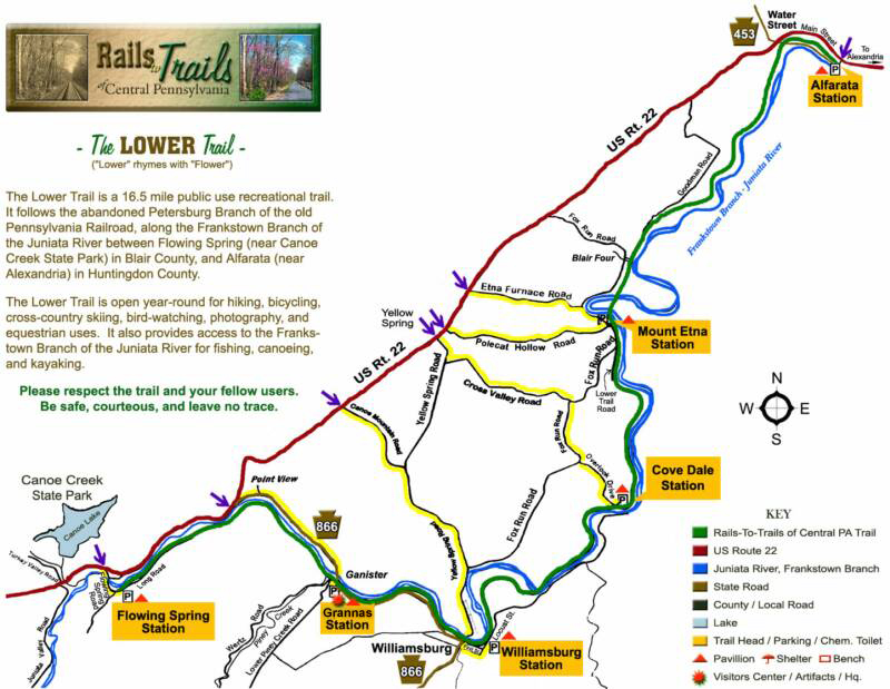
A trail map is at the bottom of this page. You can also download a pdf of this file to take along (phone coverage on the trail is spotty).
Notice!
Dilling bridge east of Williamsburg is closed as of September 2025 due to structural issues. Timeline for reopening is unknown.
Parking
Finding space for even a small truck and trailer is one of the bigger challenges to using the Lower Trail. In the summer you probably need to avoid busiest times, or you won’t find parking (except perhaps in Williamsburg). A two-horse trailer is probably best due to limited parking areas.
![]() Alfarata trailhead (west end of Alexandria): One of the larger parking areas and easy in and out from Rt 22. Also one of the busier trailheads. On weekdays, you may be able to park a rig along the edge of the lot. On weekends, it is usually full. There is moderate shade. Note that West Main St can be pretty busy with truck traffic, and the lot is fairly close to the road. When starting at Alfarata, note that the first 0.8 mile parallels Rt 22 and there is a lot of road noise. Once you pass Water Street flea market, there is a sudden transition to peace and tranquility, so hang in there!
Alfarata trailhead (west end of Alexandria): One of the larger parking areas and easy in and out from Rt 22. Also one of the busier trailheads. On weekdays, you may be able to park a rig along the edge of the lot. On weekends, it is usually full. There is moderate shade. Note that West Main St can be pretty busy with truck traffic, and the lot is fairly close to the road. When starting at Alfarata, note that the first 0.8 mile parallels Rt 22 and there is a lot of road noise. Once you pass Water Street flea market, there is a sudden transition to peace and tranquility, so hang in there!
![]() Mount Etna is a good choice for equestrians. The lot is small, but usually not too busy. On weekdays, or early or late on weekends, you may get a spot. It is very shady and there is considerable grass. Fox Run Road and Polecat Hollow Road are narrow but reasonable roads to Mount Etna. Avoid Etna Furnace Road, which is very rough and narrow. Mount Etna is a quiet area with little car traffic. Do read the “Bridges” section before going to Mount Etna!
Mount Etna is a good choice for equestrians. The lot is small, but usually not too busy. On weekdays, or early or late on weekends, you may get a spot. It is very shady and there is considerable grass. Fox Run Road and Polecat Hollow Road are narrow but reasonable roads to Mount Etna. Avoid Etna Furnace Road, which is very rough and narrow. Mount Etna is a quiet area with little car traffic. Do read the “Bridges” section before going to Mount Etna!
![]() Grannas Station is a decent choice for equestrians, as it doesn’t seem heavily used. There is limited grazing, but the Grannas Station building (owned by the trail) does have a lawn with picnic tables and shade. There is a quarry across the river from the station, and truck traffic on weekdays can be heavy, so it’s not the quietest place. See the “Bridges” section before going to Grannas Station!
Grannas Station is a decent choice for equestrians, as it doesn’t seem heavily used. There is limited grazing, but the Grannas Station building (owned by the trail) does have a lawn with picnic tables and shade. There is a quarry across the river from the station, and truck traffic on weekdays can be heavy, so it’s not the quietest place. See the “Bridges” section before going to Grannas Station!
![]() Flowing Spring trailhead (off Rt 22 near Canoe Creek state park): Access to this lot is via a fairly long and narrow lane with fences. If you get in and the lot is full, you will have to back out a long way. You may be able to park on grass along the access lane if the weather is dry; it can get muddy. There is decent shade, and some grazing. We have talked to people who have parked on the shoulder of Flowing Spring road along farm fields, but it’s hard to say how grumpy owners might get about that. This trailhead is across the river from Rt 22, so it is fairly quiet.
Flowing Spring trailhead (off Rt 22 near Canoe Creek state park): Access to this lot is via a fairly long and narrow lane with fences. If you get in and the lot is full, you will have to back out a long way. You may be able to park on grass along the access lane if the weather is dry; it can get muddy. There is decent shade, and some grazing. We have talked to people who have parked on the shoulder of Flowing Spring road along farm fields, but it’s hard to say how grumpy owners might get about that. This trailhead is across the river from Rt 22, so it is fairly quiet.
![]() Covedale is a very peaceful parking area but trailer access is a problem. If you have anything but the smallest trailer and shortbed truck, you might find you simply cannot turn around in this lot. The road in is also narrow and steep. Probably best to avoid this lot completely.
Covedale is a very peaceful parking area but trailer access is a problem. If you have anything but the smallest trailer and shortbed truck, you might find you simply cannot turn around in this lot. The road in is also narrow and steep. Probably best to avoid this lot completely.
![]() Williamsburg has a trail parking lot plus parking on public streets. The trail area is right in the middle of town, so expect to deal with cars and people. There is some shade. There is a public park west of the trail parking area, but signs say “no animals in park”. If you do park there, definitely stay off grass and go only in the parking lot.
Williamsburg has a trail parking lot plus parking on public streets. The trail area is right in the middle of town, so expect to deal with cars and people. There is some shade. There is a public park west of the trail parking area, but signs say “no animals in park”. If you do park there, definitely stay off grass and go only in the parking lot.
Water Street (on Rt 22 near Rt 453): The flea market parking lot here is large, but it’s a little unclear who owns what and whether you can park there. We have seen horse trailers parked at the west end of the lot. Note that this is right on Rt 22; there is no barrier from the highway, which has considerable fast traffic. It is quite noisy. This is a very unforgiving spot for dead-broke horses only. There is not much shade.
Mounting blocks
There are no dedicated mounting blocks on the trail. Benches and tables make remounting pretty easy anywhere.
Road crossings
Most road crossings have decent visibility and roads aren’t too busy. Williamsburg can be busy. Grannas Station is a little bit tight. Note that posts at road crossings can be a tight fit for wide horses.
Bridges
There are a number of bridges which may be scary for less-experienced horses or riders.
Alfarata area: The trail crosses under a high concrete bridge carrying Rt 22. Some horses get a little fidgety about the towering walls and traffic noise.
Water Street area: There is one short bridge behind the flea market which you will cross if you start at Alfarata. It has a wooden deck and wooden fence railings. It often has water rushing beneath it, and some horses just don’t like that.
Mount Etna area: There is a very short covered bridge just east of the trailhead. It has a wooden deck and side railings. The roof is somewhat low. It is only a few feet above a small wet area, minimally scary.
There are two long railroad bridges close together a bit east of Mt Etna. These are decked with fiberglass panels which make a lot of noise, especially if your horse has shoes. The floor is solid panels, so you cannot see down through it. Railings are about four feet high. Both bridges are pretty wide. One bridge has solid sides, the other is board fence. Whatever you do, DO NOT go on the private lane side of the bridge closer to Mount Etna, which has VERY DANGEROUS gaps in the decking!
Williamsburg area: There is one long railroad bridge 1.75 miles east of Williamsburg. Sides are about 4 feet high. The main trail crosses noisy fiberglass panels, but the grass berm uses a wood-decked span. CLOSED INDEFINITELY, SEPT 2025
Grannas Station: Just west of the station and parking lot there is a modern steel trail bridge. It is a very noisy bridge, especially if your horse is shod! You can see through the side railings, but they are tall. The bridge is quite narrow, much narrower than the actual railroad bridges.
Bridge-free stretches: Mount Etna to Covedale. Williamsburg to Grannas Station.
Trail surface
In most areas, the main trail surface is crushed limestone. Horses should stay on grass berms (either side in most places) as much as possible, especially when the ground is soft. Brush is cut back so this is not a problem.
Williamsburg area: The trail is asphalt between Covedale (3.5 miles east of Williamsburg) and a short distance west of town. In most areas there is a grass berm you should ride on, but unshod horses should use caution in areas like the High Street crossing in Williamsburg, where you may be on paving.
West of Grannas Station, there are extra wide grass berms which are nice for letting your horse blow off a few oats.
Caution: The new connection to Canoe Creek park involves riding on blacktop and public roads for a considerable distance (see below).
Trail width
West of Grannas Station, there are extra wide grass berms, which are nice for letting your horse blow off a few oats.
East of Flowing Springs, there is a long stretch of trail with a board fence to divide off a private camp lane. Because of this there is very little grass shoulder. Please pay attention as you will share the narrow lane with bicyclists and walkers. Please try not to tear up the trail.
Peacefulness
(Listed in east to west order)
![]() Alfarata to Water Street: Lousy. Get it over with as quickly as possible!
Alfarata to Water Street: Lousy. Get it over with as quickly as possible!
![]() Water Street to Mount Etna: Excellent! No road crossings. Very quiet.
Water Street to Mount Etna: Excellent! No road crossings. Very quiet.
![]() Mount Etna to Covedale: Very good. Isolated and quiet. A few camps.
Mount Etna to Covedale: Very good. Isolated and quiet. A few camps.
Covedale to Williamsburg: Nice and quiet at first, but transitions to town setting with traffic and people near Williamsburg.
Williamsburg to Grannas Station: Pretty good, getting out of town but does parallel road.
![]() Grannas Station to Flowing Spring: Pretty good. Some noise from trucks to quarry, and Rt 22 traffic is across river.
Grannas Station to Flowing Spring: Pretty good. Some noise from trucks to quarry, and Rt 22 traffic is across river.
Grazing areas
Alfarata has a fair amount of grass. Mount Etna has lots of shade and grass. West of Grannas Station, the trail has wide grassy berms. The yard of Grannas Station (owned by the trail) offers some grazing. Flowing Spring has some grazing.
Water
No running water is provided anywhere on the trail. Access to the river is not easy in most places.
Fuel and supplies
Martin’s General Store on Rt 22 across the river from Alfarata trailhead has easy fuel access for truck and trailer. Martin’s in Williamsburg is reasonable. Melnik’s on Rt 22 is ok. It is 5.1 miles west of Flowing Spring trailhead.
The town of Williamsburg has several food (and dessert) options close to the trail. A few food options are at Alexandria (east end of trail). Many more choices are 8 miles east of the trail in Huntingdon, or 6 miles west of the trail in Hollidaysburg.
There is a Tractor Supply 9.5 miles east of Alfarata trailhead on Rt 22.
Manure disposal
There are no designated facilities for disposing of manure. Please clean up after yourself whenever possible. If you need to dispose of manure, please put it in overgrown areas away from houses and pedestrian areas. Be a good neighhhh-bor!
River access
The railroad was built to be well above flood level, so it is tough to get to the water.
![]() Flowing Springs has a good trail to the river. When water is low, there is a landing of smooth river rocks and the water is shallow and clear. This is the best horse access we have found.
Flowing Springs has a good trail to the river. When water is low, there is a landing of smooth river rocks and the water is shallow and clear. This is the best horse access we have found.
![]() Alfarata has river access for kayakers, but the trails are narrow, somewhat steep, and can be slippery. We suggest not trying to access the river here with horses.
Alfarata has river access for kayakers, but the trails are narrow, somewhat steep, and can be slippery. We suggest not trying to access the river here with horses.
![]() Grannas Station has a small river access but it is steep and may be slippery.
Grannas Station has a small river access but it is steep and may be slippery.
Mileages
(All are ONE-WAY distance)
- Alfarata to Mount Etna: 5 miles
- Mount Etna to Covedale: 2.75 miles
- Covedale to Williamsburg: 3.5 miles
- Williamsburg to Grannas Station: 2 miles
- Grannas Station to Flowing Springs: 3 miles
Canoe Creek state park access
In 2021, PennDOT completed a connection from Flowing Springs trailhead to Canoe Creek state park. Unfortunately it is not possible to access the park without going on public roads, although the park is working on a trail connection.
From the end of the Lower Trail at Flowing Springs road, you must ride about 1/4 mile on the road, crossing a small and a large road bridge decked in white concrete. Railings are not very high. You then turn left on the former Weller Road–which is now trail–to a new tunnel with lights under Rt 22.
Once on the north side of Rt 22, you are on Beaver Dam Rd (public road) and are still 1/3 mile from the near park entrance. Note: Even if you access the park this way, you are across the lake from the park’s riding trails, trailer parking areas, and most features. There is no trail that connects the two areas at this time; you would have to ride a considerable distance on public roads.
(Revision 1)