Summary
One square mile of mature forest land provides a couple pleasant, shady loops up to 5 miles, but some grades are steep and trails are fairly rocky. Shoes or boots are recommended. Stream crossings may be deep after rain.
While poking around for new places to ride horses in Central Pennsylvania, I stumbled upon Clearfield county’s visitor website ![]() , which mentions Wopsononock Natural Area for horseback riding. Familiar with “Wopsy” mountain outside Altoona, I had never heard of this area… and don’t natural areas prohibit horses?
, which mentions Wopsononock Natural Area for horseback riding. Familiar with “Wopsy” mountain outside Altoona, I had never heard of this area… and don’t natural areas prohibit horses?
Digging revealed this is former Camp Wopsononock, a Scout camp until the county turned it over to DCNR ![]() in 2016. The 578 acres of land are high-quality, mature woodlands, offering tons of shade but often rocky terrain.
in 2016. The 578 acres of land are high-quality, mature woodlands, offering tons of shade but often rocky terrain.
Unfortunately there isn’t much information about the tract online, and descriptions of it are vague and misleading, so I thought I’d share information as I piece it together.
Getting There
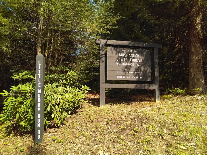
The entrance to the property is Little Muddy Run Road off of PA 253. According to the sign, it is the Wopsononock Tract. Nothing about a natural area.
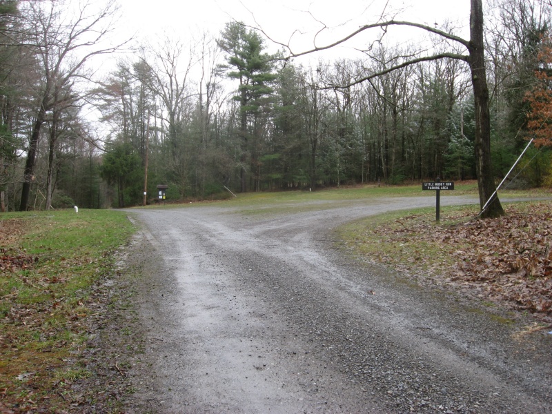
Just off PA 253 there is a decent size grass/gravel parking area large enough for several trailers, though it’s on a bit of a slope. There is some grass for nibbling. The south loop of Dawn Trail heads right off this lot. If you stay straight on the road it takes you to the north loop of Dawn Trail.
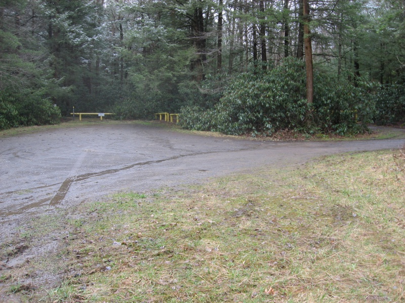
If you drive straight in on the road about 1/4 mile, there is another lot off to your left before the yellow gate. It’s a little smaller and a little tighter access, but flat. You could fit more than one small trailer, but turning around may be an issue.
Nearby Little Muddy Run may have water for horses but there is no running water and no facilities for humans, just parking lots! There is plenty of shade. You’d think DCNR could maybe provide a picnic table.
Note: Do not turn in at Williams Road (north of Little Muddy Run) as this quickly dead ends at a fenced pond and there isn’t much space to turn around. DCNR claims there are picnic tables here but I have not found them.
Wopsononock Tract Location:
- On PA 253 (just south of PA 453)
- just northeast of village of Allemans
- at Clearfield/Cambria county line
- Gulich township
- 12 miles from Tyrone
Directions from Tyrone:
- take PA 453 (Janesville Pike) west from Tyrone about 11 miles
- turn left on PA 253 and go about 1 mile
- entrance road is Little Muddy Run Rd on left (East) side
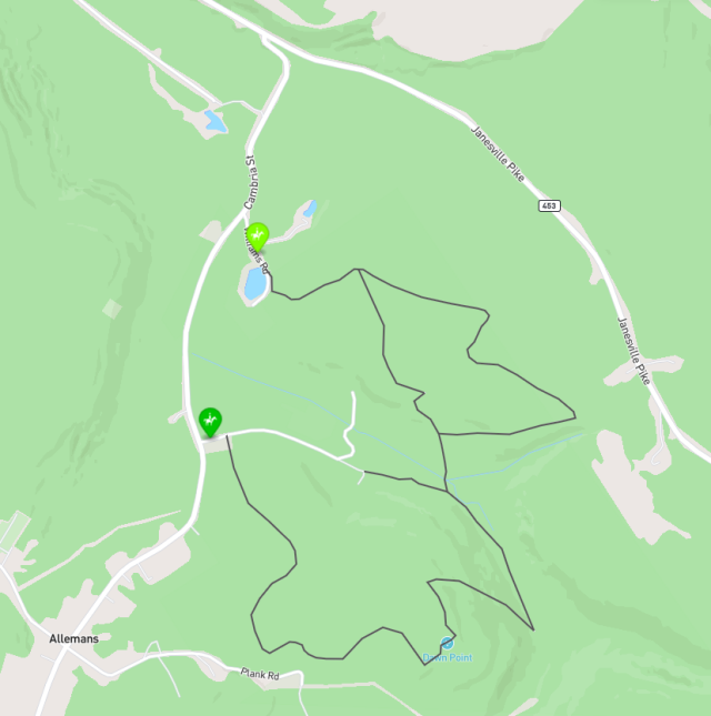
Horse Riding Map of Wopsononock Tract
We created a custom Mapbox map that shows horse riding trails in this area.
Mapbox – Wopsononock Tract Horse Riding ![]()
We’ll try to update this map in 2024 to correctly show stream crossings discussed below.
Trail Profiles
These images and links give distance and elevation profiles. Click on images for large versions.
Dawn Trail North and South
Doing both loops in a figure-8 gives a trek of about 4.5 to 5 miles. Although the computers says 550 feet elevation change (1100 up/down combined), GPS on our ride said more like 1300 feet! You will find significant grades on both loops, and plenty of rocks.

Dawn Trail South (from parking)
This 2.5 mile loop has about 350 feet elevation change (700 feet up/down combined). The east end from Dawn Point to the stream is pretty steep, probably 10-15% (the profile doesn’t show this correctly). You’ll have to decide whether to do it up or down!

Dawn Trail North
This 1.8 mile loop from the stream crossing on Little Muddy Run road has about 300 feet of elevation change (600 feet up/down combined). The branch to the lake adds 0.3 miles and 150 feet, one way.

Dawn Trail North (from parking)
This 2.9 mile loop has about 400 feet elevation change (800 feet up/down combined). The branch to the lake adds 0.3 miles and 150 feet, one way.

Our Test Ride
In June 2024 we visited and rode both loops of Dawn Trail in the evening. Despite a rainy spring, bugs weren’t too bad and the stream crossings were dry.
This view from gpx.studio shows the directions we rode and mile markers, as well as an elevation profile.

A view from geojson.io gives an idea of the wooded character of the trails. As you can see, our GPS track doesn’t agree so well with trails mapped online. Maybe we can tweak the trails in OpenStreetMap.
Our track says 5.2 miles and 1300 feet (up+down) with an average speed of 2.7mph for a moving time of two hours.

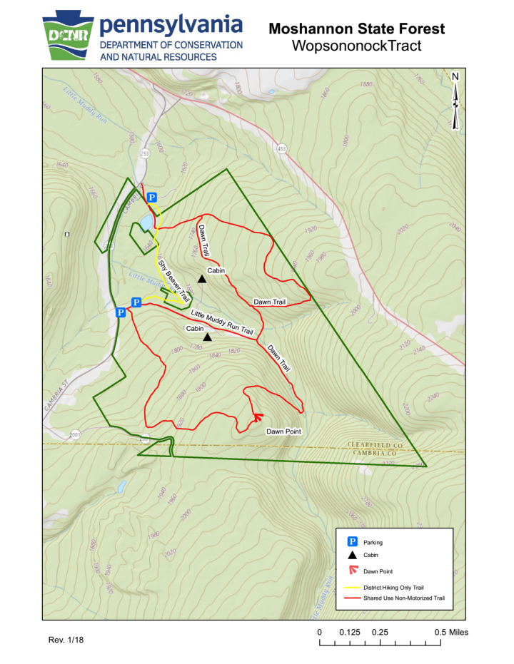
Trail Map
In 2022 DCNR came through with an official map, though it’s not very detailed.
Online info suggests that neighboring private property owners are not particularly friendly, so please try to adhere to the trails and boundaries shown.
You can download the map as a pdf file to print or take along (1.2MB).
Stream Crossings
The tract can sometimes be wet. The ranger who got me the official map said they “needed to add some bridges” at stream crossings.
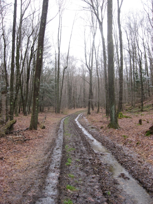
I explored in April 2024 after several days of rain and found water crossings on Dawn Trail were deep and fast. When we rode in June these were completely dry!
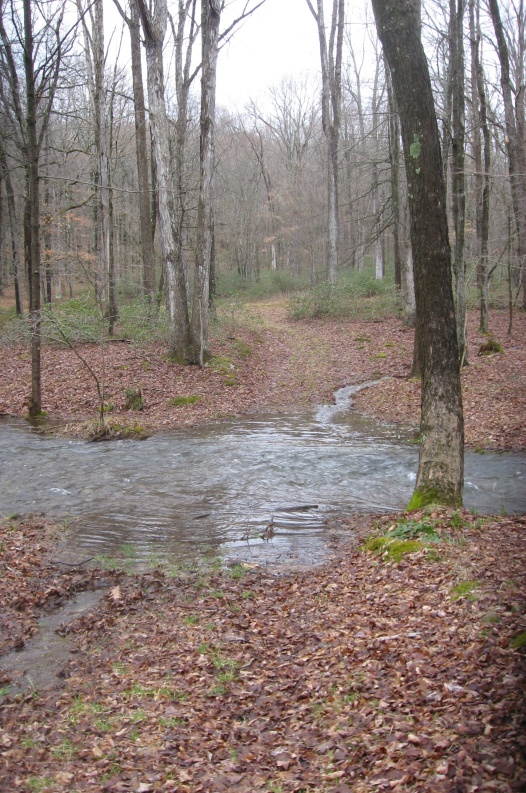
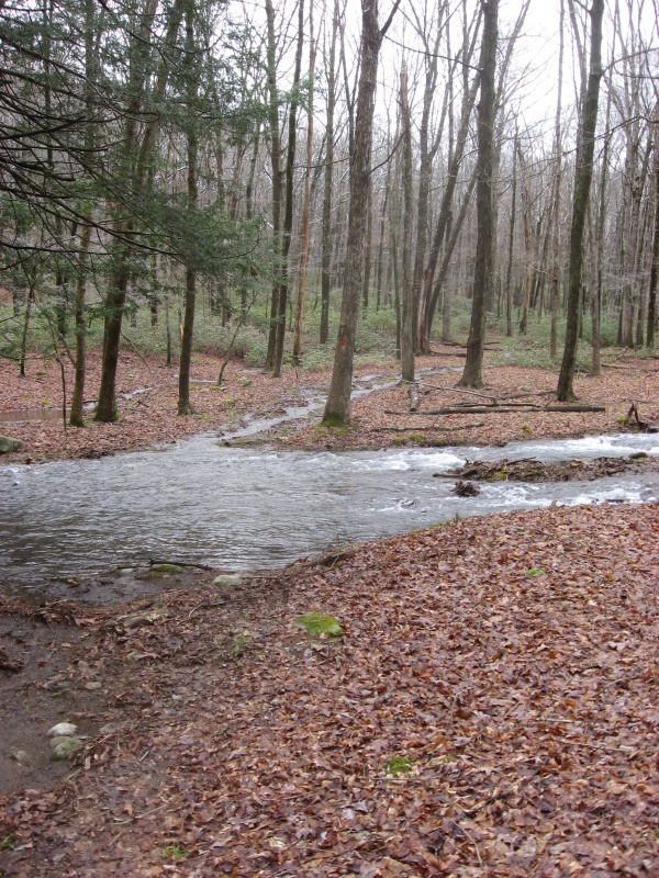
Unless your horse is a real water bug, you may want to avoid these trails after a lot of rain.
These is one swampy area on the south loop of Dawn Trail. Most of it can be skirted.
Trail Notes
Both loops of Dawn Trail are multi-user so you may encounter bicycles and hikers. I pass the parking area fairly often to ride at Prince Gallitzin and have never seen anyone parked there, so usage is probably minimal.
Dawn Trail South
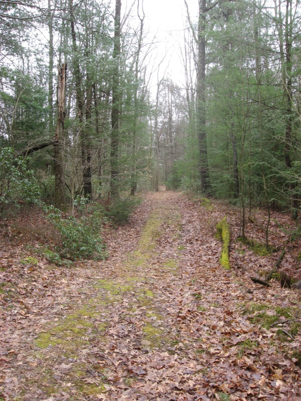
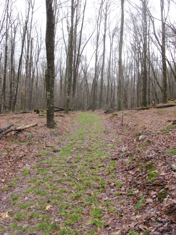
The south loop of Dawn Trail heads off the main parking area. It’s a double track trail climbing through mature woods, with a mix of dirt and rounded rocks. It climbs at ~10% slope going south of the parking lot (counterclockwise loop). There is one swampy area where you’ll probably encounter mud on and off for maybe 300 feet. There is a pipeline right-of-way you can use to shorten the route a bit, but it’s not much difference and it’s not as scenic as the woods.
Towards the summit it gets pretty consistently rocky. In places the rocks are uncomfortably large and easy for your horse to trip over. Don’t get too excited about “Dawn Point” shown on maps; it’s grown up and any view that was once there is blocked in summer.
The descent down to the stream is steep. While online maps show it as gradual, it’s actually more like 10-15% and pretty rocky.
The other end of Dawn Trail’s south loop is grassy, but there are annoying goober rocks mixed in that make it a little slow. This is near the junction of north and south loops and the stream crossing on Little Muddy Run road.
Little Muddy Run trail is a gated road back to a couple camps. It gets quite muddy and rutted after rain, but you can skirt most of the water and mud on the shoulders.
Dawn Trail North
The north loop turns off Little Muddy Run road at a significant stream crossing. The first short section is a gradual climb and mostly dirt/grass. After the trail turns right (to the east) it begins a fairly long climb at 10-12% grade, becoming more rocky. Your horses may want a break at the top.
Atop the hill the rocks are pretty obnoxious as you begin a slow descent towards the lake. You intersect Shy Beaver hiking trail near where the trail down to the lake branches. Since the lake is a fenced water supply and not very scenic, there isn’t really much reason to ride that leg.
A descent on the west leg seems much easier than the climb on the east. The trail is less rocky, and you get down off the hill pretty quickly. It’s easy to get confused at the junction when you close the loop, and turn the wrong way onto a trail to a private camp. There are no signs, so we just continued out the camp driveway and got back to Little Muddy Run road.
Spring
While riding, see if you spot the big spring with its little wooden bridge and a stone monument to the family which donated this property to the Scouts.
Updates
2024.06.09 - updates based on ride of both loops
2024.04.05 - added trail pics and water info
2024.03.02 - added trail profiles