Summary
Beautiful park offers a good number of trails with good footing and reasonable slopes. Plenty of parking in a few areas, and amenities like restrooms. running water, and plenty of places nearby to get lunch, snacks, or even an adult beverage!
Prince Gallitzin state park offers approximately 16 miles of beautiful horse riding trails up on the Allegheny plateau around Glendale Lake. Adjacent State Game Lands also offer trails. Hopefully this up-to-date guide written specifically for horse riding will give you accurate and thorough information you need to know for horseback riding there! Since quite a bit of information floating around is sadly outdated, we hope this helps.
People are always asking about Glendale Stables. There is no horseback riding concession at the park where you can rent horses; it closed years ago.
Custom Trail Map for Prince Gallitzin
We are experimenting with a new “slippy” map of horse trails at Prince Gallitzin using MapBox. This is an excellent map offering a variety of basemaps including aerial view and OpenStreetMap.
GeoJson Map – Prince Gallitzin ![]()
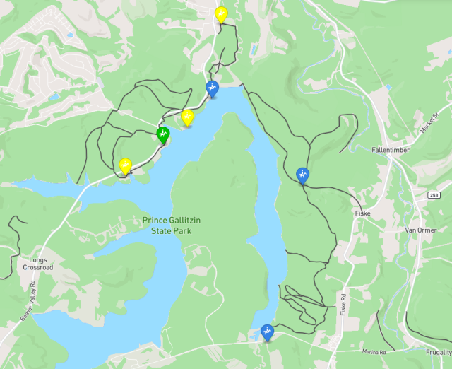
Parking areas for horse trailers are marked with the following key:
 official horse-trailer parking areas
 horse trailers fit, best for off-peak/off-season use
 usable but not ideal (small, tight access, noisy, etc.)
Other Trail Maps
The park’s own trail guide is pretty good, better than average, and the brochure contains descriptions and distances for all the horse trails. You can view it from the webpage:
Better yet, pick up a physical brochure at park headquarters on the south side of the lake (or stations at most parking areas) and disconnect from your phone for a little while.
Riding Areas
Broadly speaking there are two horse riding areas in the park:
- North – Shomo Fields – north of Beaver Valley Road
- East – Bater Patch trails – west of Fiske Road
Shomo Fields is north of Beaver Valley Road and Beaver Valley Marina. Bollinger Trail parallels the road and gives access to loop trails in the Shomo Fields area. This is nice because it gives options for varying riding distance. The downside is Bollinger Trail is kind of noisy because of the amount of traffic on the road. Be careful crossing the road and pulling onto it with your trailer! In good weather it gets quite busy, visibility is poor, and people often drive too fast. The park is working with PaDOT and the township to improve trail crossings, thankfully.
Bater Patch is on the lake’s east side, and west of the villages of Fallen Timber and Fiske. It has longer trails, including some which were once part of a hire-a-horse concession at the park (which closed years ago). The main loop is Old Glendale Road and Hagarraty Trail; see below for more information. There is also a section of Shomo Run Trail which loops, but most of that trail is out and back.
Note: At the village of Fiske where you turn back to Bater Patch there is a small church where you might park to ride back the dirt road to the actual trailhead. Be warned that there is a house along the access road with large and obnoxious dogs which are not contained. It’s easy to mistake their driveway for the road. You were warned!
Horse Trailer Parking
Please see our new slippy map (at the top) for parking suggestions!
There are several areas suitable for parking horse trailers at Prince Gallitzin:
- Beaver Valley Marina
- Beaverdam parking lot
- Bater Patch trailhead
- Firing Range access road
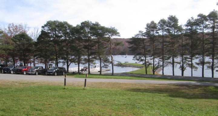
Beaver Valley Marina is the “official” horse trailer parking area. It’s primarily for boat launching with lots of parking for boat trailers. The upper lot is gravel and grass and is best for horses. It is a bit close to the road, which can be busy, but there is a bank separating them a bit. There can be a lot of traffic in the marina, with boats and boat trailers coming in and out and many people about. Don’t expect it to be the quietest place on earth to get tacked up and on your way. On a Sunday in late October, 6 horse trailers pulled in after us!
Beaverdam parking lot is closest to the actual dam, nice if you want to access trails at the east of the park (by crossing the dam). Officially it is said to be too small for trailers. In reality, the lot was extended (may not appear on all maps or aerial views) and could certainly take one smaller trailer in the slow season. At busy times you should not tie up this lot, as it is mainly for kayakers and fishy people.
Bater Patch trailhead is a tiny and remote dirt lot accessible via the village of Fiske on the east edge of the park. You might be able to squeeze in two small horse trailers, but not much more. This is a convenient access to Old Glendale Road and Haggaraty Trail, but just understand that it’s small, there are NO facilities there at all, and it is back a 1/2 mile long one-lane dirt road that’s not exactly smooth. If you get back there and it’s parked up, you may get plenty of practice backing your trailer!
The game commission Firing Range (southeast corner of lake) has a small gravel parking area just off Marina Road. It appears you could park a horse trailer there to access Shomo Run Trails from the south end, as it’s not the actual parking for the gun range. There is significant gun noise, so it’s not a particularly peaceful spot. It appears you can connect to Shomo Run Trail directly across the road from the parking area, but that’s not shown on maps.
Mounting
When you have a big horse, it’s nice to have easy mounting spots!
Most parking areas have at least one picnic table. But at busy times it may not be easy to find a place to mount your horse.
Picnic tables at Beaver Valley Marina tend to be in the congested area near the water, and not the greatest for mounting.
It sure would be nice if the park or a local volunteer group could build a mounting stand at Beaver Valley. Ohio parks can teach you how 🙂
Grazing
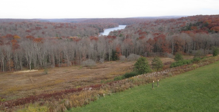
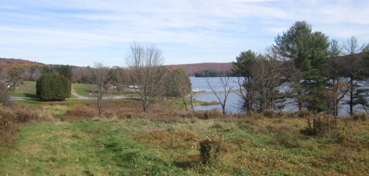
There is plenty of grazing at Beaver Valley Marina, or any of the bigger access areas. Headache Hill would also be a good grazing stop with plenty of parking, and you can take in the view from the overlook.
Bater Patch is deep in the woods with little grass.
Bridges
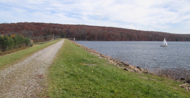
The biggest “bridge” issue is probably the dam itself: the overflow at the east end is crossed by a high span with a concrete deck and open chain-link fence sides. Moving water is visible on both sides, and it’s down pretty far. It makes strange ringing metallic noises with steps. If your horse isn’t an experienced trail horse, crossing it could be interesting. There is one small bench on either side of the dam where you might remount if you have to walk this one, but the west one is quite a distance from the overflow bridge–the dam is about 1/3 mile long.
Another bridge crosses the overflow stream down off the dam breast to the north. It is intended for snowmobiles. It is wooden decked with no railings. It is five feet wide, approximately 40-50 feet long, and about six feet above the stream. Thankfully my horse wasn’t too bothered by it, but some may not like it.
Bollinger Trail has a small covered bridge west of Beaver Valley marina. It is 30 feet long with a wooden deck, and crosses Pickerel Pond. The roof is less than 7 feet high, not much for a rider on a tall horse! You can easily bypass it on land just north of the bridge.
On our first trail we encountered a small and easy bridge with a wooden deck and steel railings. It appears there are a few of those scattered around, but they are in good shape and unlikely to be an issue for most horses.
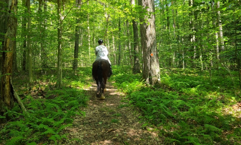
Trail Conditions
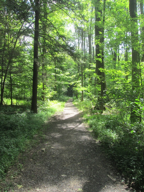
We’ve not been on all the trails, but it seems like they are mostly dirt or grass, with minimal rocks. Small gravel is in a few high-traffic areas like gates. Overall the trail surfaces are just about ideal.
Expect to encounter a few swampy areas, but most are small enough to be skirted or bypassed easily.
Trail grades all seem easy. While online mapping shows grades up to 10-15%, these seem to be short. We were told Rhody trail down to the lake might be the steepest area, but still not really bad. Westrick and Gates have some hills. Bollinger has a couple steep spots but they are short.
Trails are blazed (colors are listed on the website trail descriptions ![]() but not the printed brochure). Park management has nicely marked most junctions with posts indicating where each branch takes you (but as of 2023 some are missing).
but not the printed brochure). Park management has nicely marked most junctions with posts indicating where each branch takes you (but as of 2023 some are missing).
Woods tend to be a mature mix of deciduous and conifers. There are a few open areas, mostly along the lake, though most of the pastures are grown up with bushes and some trees. It’s generally a really pretty place to ride, especially in spring and fall.
Bugs
We asked the park naturalist how bad horseflies and biting flies are in the summertime and got a noncommittal answer. Expect that they are probably bad due to all the wet areas. Since the park is high, there may at times be enough wind to limit fly problems, but spring and fall may be your best bets.
In late July after several fairly wet weeks, biting flies (deer flies?) bothered the horses’ ears in many areas, a few greenheads were around, and a few larger horse flies were seen. Not horrible, but a rump cover and fly mask while riding are recommended. And lots of fly spray. And a fly whisk.
After wet periods, gnats can be a problem in the woods. We had issues on a couple rides in September. Again, a riding fly mask is probably a good idea.
In the fall, I picked up a tick in just a short time walking only on mowed paths. So check you and your animals after a visit.
Loop Trails
As we explore, we will add info on some options for horseback riding loop trails.
Beaver Valley Marina to Old Glendale Road is a popular loop. Start at the marina, follow Bollinger Trail northeast, cross the dam breast, and do a 3 mile loop of Haggaraty Trail/Krise Road and Old Glendale Road. Total distance is almost 6 miles, with about 500 feet of vertical. Haggaraty Trail has more up and down, while Old Glendale Rd is pretty flat, so you might want to do the hills first. If you park at Beaverdam it shaves 2 miles off the round trip (but see notes under Parking).
Beaver Valley Marina to Gates Trail (east) is a nice easy loop. Start at the marina, follow Bollinger Trail northeast to pick up the east branch of Gates Trail. There is a bit of a climb up away from the road, but it’s not very long. After meeting the west branch of Gates trail continue west across Swartz Road and straight ahead onto Rhody trail. After climbing a bit you turn left on Herman Fields Road (it is a trail). There is a slight climb then it’s pretty level through overgrown pastures to an easy descent back to the road right across from the marina. There are a couple damp spots. About 3 miles.
Map of Gates Trail (east) loop ![]()
Beaver Valley Marina west-east loop is a pleasant 3.5 mile ride. Start at the marina, follow Bollinger Trail west through Pickerel Pond fields where you pick up Westrick Trail to cross Beaver Valley Road. Stay on Westrick up to Herman Fields trail, go left and continue through pastures and then woods down to Rhody trail. Turn right, cross Swartz Road onto Gates trail (take either branch of Gates trail at the top of hill; right branch gives 3.5 miles, left branch 4). Either branch takes you down to Beaver Valley road again. Follow it west to a crossing which puts you back near Beaver Valley Marina and your start point.
Map of Beaver Valley west-east loop ![]()
Trail Notes
Gates trail: The trail jogs a bit where it crosses Swartz Road. Swartz Road can be a little busy, use caution when crossing. Gates does climb a good bit if you head east from Swartz Road. Mature woods, lots of shade.
Reed trail: Nice woods trail with a number of damp spots. Most can be skirted. A little bit of a climb, not bad.
Herman Fields trail: Most of it is a double track former farm lane through some overgrown pastures. The north end narrows in mature woods, with a modest hill near the junction with Rhody trail. A few damp spots around one meadow.
Westrick trail: Nice path through mature woods. Bit of a climb off Beaver Valley road but nothing crazy. Connects with Herman Fields at some pastures.
Bollinger trail: Acts as a connector spine trail along Beaver Valley road. Fairly sunny and is unfortunately a bit noisy at times due to traffic. Be careful crossing the road! There are a few steep hills but they are short. Some stretches are a bit squishy, both in the woods and in open fields, thanks to poorly drained soils. Nearby Patton once had a massive brick and tile factory (Patton Pavers are all over the world), so you can guess that soils tend towards clay and don’t drain the best.
Old Glendale Road: We haven’t covered all of it, but it seems like a very easy wide trail, as you’d expect from a previous road. Footing is a mix of dirt and gravel. Shaded with beautiful mature woods and a few stands of hemlocks, with glimpses of the lake.
Haggaraty trail: We haven’t ridden it, but passing by in late summer it appears a bit overgrown compared to most of the trails. Definitely doesn’t look flat!
Water
Bring your own water for you and your horse, or at least a bucket to get water out of the lake or a stream. I had little luck finding a hydrant at any of the areas I checked. Water fountains are apparently turned off due the the plague, and none of them seem to have faucets anyway.
At Beaver Valley Marina, volunteer hosts have a hydrant at their RV with great water pressure. If you ask nicely you can probably use it… assuming they are there and it isn’t turned off for the winter. Other areas may have similar hosts with running water.
Or there is the lake. With all the boat launches, you can probably wade your horse in and bathe except during busy boating times.
Hunting
Something that should be emphasized on the park website and is NOT: most of the park is open to full hunting. In fall weather you will likely encounter hunters and gunfire on your ride (and should obviously wear hi-viz orange!). Hunting in PA is prohibited on most Sundays, meaning Sundays may be pretty busy with horse users trying to avoid being shot.
Facilities
Beaver Valley Marina has real restrooms with running water which seem to be open even out of season. There are a modest number of picnic tables, some benches, and a peninsula with benches out in the lake.
Beaverdam has pit restrooms and no running water. One picnic table.
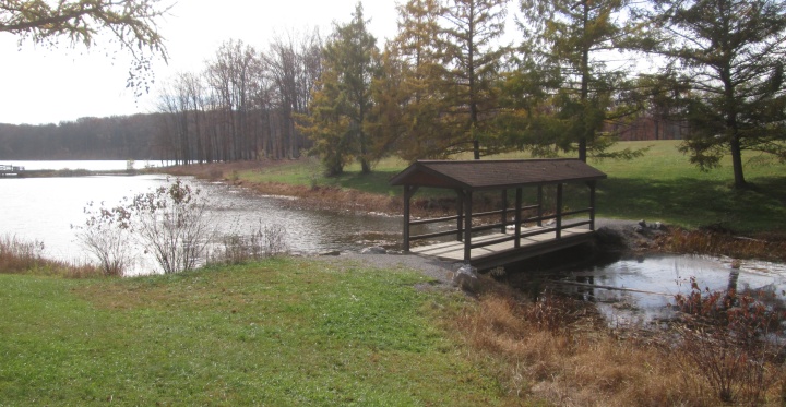
Pickerel Pond has real restrooms, a water fountain, a playground, picnic pavilions, plenty of picnic tables, and a wide open field, but may be crowded in warmer months. Not recommended for trailer parking, but at slow times there is plenty of space.
Bater Patch has no facilities. The east end of the park is undeveloped compared to the rest.
Supplies in the Area
Noel’s Drive-In is southeast of the park at the intersection of Marina Road and St Augustine Rd. It’s across the lake from Beaver Valley Marina, so maybe 10-15 minutes. They claim the “area’s best soft serve” and it is good (probably Galliker’s). Unfortunately they seem to goof up every food order and prices are a little high! Noel’s gets top billing because of the shady, wooded area in back with picnic tables. There is usually space to park at least one horse trailer out of the sun, making it the spot for lunch and snacks with your horses on a hot afternoon.
Pennywren’s Store has gas and diesel and food and ice cream at the intersection of Beaver Valley Road and Rt 53, northeast of the park. Open 7 days. Good size parking area. Ready-made sandwiches, varied hot food menu at decent prices. Soft serve and Galliker’s ice cream are a bit expensive. Very convenient if you are going to Beaver Valley Marina parking. Unfortunately no shade at all, no place to graze.
Route 53 Country Store near Fallen Timber east of the park has gas (no diesel), a small food menu, and Hershey’s ice cream. Sadly, as of fall 2023 they seem to be having major staffing issues and hours have been trimmed dramatically, so it’s hard to recommend them if they aren’t predictably open. They have the mild/medium/hot hoagies which for some reason are a staple of the area–if you like onions! It’s just south of the intersection of Rts 253 and 53 . No shade, no grazing.
Pirates Cove is southwest of the park and has ice cream, food, and beer! Haven’t tried it yet. Probably no shade, no grazing. There is a distillery next door, if your ride didn’t go so well 😉
Houser’s Subs is a recommended stop if you come off of I-99 at Bellwood. They have great subs at fair prices, friendly service, offer breakfast, have ice cream and snacks, and are open 8-8 on weekends (though they close on holidays). Call 15-20 minutes ahead to pick up sandwiches on the fly (814 742 8721). Parking lot is small, but pull around the corner onto side streets to park your rig. Definitely give them your business instead of wasting money at overpriced chain convenience stores.
There are also options in the town of Patton west of the park, but the intersection of Glendale Lake Road and Rt 36 is bad if towing a trailer. You may just want to support the stores closer to the lake.