Summary
Nearly 4000 acres of state game lands offers dozens of miles of horse riding trails plus quiet adjacent roads. Very secluded and quiet, no facilities and not much nearby for food or fuel.
Notice!

As of early 2024, there is again a push to approve hunting on ALL Sundays of the year. This would effectively end use of State Game Lands for safe outdoor recreation by hunters.

Please contact your state representatives and tell them you believe one day of the week should remain non-hunting in Pennsylvania to enhance outdoor recreation opportunities!
State Game Lands 174 near McGee’s Mills, Pennsylvania, offers more than 30 miles of horseback riding trails. We believe this is the most horse trails on any game lands in the state.
In the 1870s this remote area was called “The Wilderness” and even today it is remote. It contains the mining ghost towns of Sidney and Keal Run.
Note that another state game lands (SGL 262) is just southwest near Glen Campbell and Smithport. It also has many miles of horse trails on thousands of acres of reclaimed strip mines.
Details
State Games Lands 174 is nearly 4000 acres of land. It lies along Rt 36 northwest of the village of McGee’s Mills, which is the intersection of US 219 and PA 36. This is 25 miles southwest of Clearfield and 13 miles southeast of Punxsutawney at the corner of Jefferson, Clearfield, and Indiana counties.
Much of it was mined for coal, so it’s not pristine forest, but it’s still nice open space. There are areas that are clearly disturbed, and some areas of coal waste. Much is returning to deciduous woods; some reclaimed areas are open meadows or planted pines. Most of the acreage is wooded; the southern portions were more recently mined and parts are more open.
There are lots of gas wells, and many trails are well access roads which often don’t go too far. The land is by no means boring or flat: there is actually quite a bit of terrain.
We haven’t ridden horses here yet, we just scouted it out a couple times and hope to visit with a group soon.
Map
We created a slippy map of the area, with some of the larger parking areas marked.
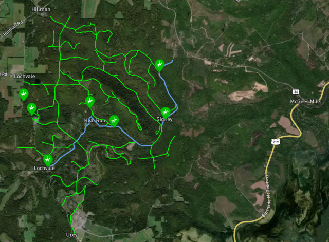
The access road through the lands (Harkleroad Road – Bennett Road – Sidney Road) is also quite practical for riding. It is dirt or gravel and seems unlikely to have much traffic.
Bits and Pieces
The area contains two named locations, Sidney and Keal Run, which were coal mining villages in the early 1900s. It might be fun to explore and see what traces of these towns can be found.
A branch of RJ Corman railroad passes through the land, but this line has been out of service for some time and seems unlikely to ever be active again. You probably don’t have to worry about coal trains!
The north branch of Bear Run is a native trout stream and scenic, although the west branch is contaminated with Acid Mine Drainage.
Trails
Most trails are gated woods roads, with grass or dirt footing. Some of the trails are gas well access. These are usually dirt. They may be muddy in certain seasons due to service truck access.
Most trails are gated at roads. Some are easy to get past with horses, others may require some effort. Horse driving is probably not an option, other than on the main roads and some well access roads that are not gated.
The main access road through the lands (Harkleroad Road – Bennett Road – Sidney Road) is practical for horse riding or horse driving. It is dirt or gravel and unlikely to have traffic. It is very useful for connecting different trails and completing loops.
Quiet?
Outside of hunting, it’s unlikely the area gets many visitors. A modest number of horses stand in fields on the borders of the lands, so there is probably some local use. One aerial view we examined showed a horse trailer at one of the lots.
Because of the large acreage and the location away from cities, probably not many hikers or bikers use these trails. Chances are you will find this area to be very quiet and secluded for much of the year.
Access Rules
Like all state game lands with “designated trails” for hiking, biking, and horseback riding, you cannot use the trails during certain hunting seasons.
The rules are confusing. We’ve tried to clarify:
- You can always ride on roads which are open to public travel
(it may not be very safe during hunting seasons!). - You can ride on Sundays year-round except the new Sunday-hunting days
(which are currently only in the fall) - NO riding from…
last Saturday in September through the third Saturday in January
(but is permitted on non-hunting Sundays). - NO riding before 1 pm from…
second Saturday in April through the last Saturday in May
(but is permitted on non-hunting Sundays). - Designated trails which allow horse riding should be marked
with a horse symbol
Safety
Remember, these are first and foremost hunting lands. It seems wise to ALWAYS wear fluorescent orange when riding in these areas.
Parking
Unlike so many state parks and forests, parking areas that fit horse trailers are numerous at SGL 174. Many are big enough to hold two smaller trailers. Some lots could easily hold a number of large trailers.
We’ve marked a few more promising parking areas on the map. If we get more information, we will add it. Don’t worry about parking; it shouldn’t be a problem.
Some larger parking areas we noted may be gated at times of the year. Dates of access seem needlessly complicated! Just be flexible and know you may not get to park exactly where you expect.
Facilities
As with most State Game Lands, there are no facilities on site, and location is in the middle of nowhere. Bring your lunch, and be prepared to water the bushes.
Nearby Supplies
There is a tiny store just north of McGee’s Mills on Rt 219. No fuel, sketchy fried food, NO public restroom.
Mahaffey (a few miles north on 219) has a general store/hardware/fishing/gas station/restaurant/ice cream shop (!) which is open 7 days, but closes at 2pm on Sunday. Gas/diesel are available 24 hours with a credit card. Arrow store has pre-made pizza and sandwiches but no public restroom. Broken Arrow restaurant has a reasonable menu, decent food, fair prices, friendly people, but the restroom is “customers only”. All this amazing stuff is on Rt 36 south at the far end of town.
Burnside (south on 219) appears to have a store with gas.
Grampian (13 miles north on 219) has a convenience store with fuel.
Puxsutawney (13 miles north on 36) is a sizeable town with stores and restaurants (and a groundhog and a movie about the town).
Clearfield is 25 miles north via 219 and has lots of stores and a few restaurants–some of which are ok. The Toasted Monkey bar/restaurant along the way in Hyde PA is kind of amusing after a day of harness racing at the Clearfield Fair.