While looking at State Game Lands 174 as a place to ride horses, I became a bit curious about locations marked Sidney and Keal Run on the map. I couldn’t find pictures or much else about these ghost towns. Eventually I did turn up some information but it took considerable effort, so I thought I’d share some of what I managed to learn. It seems a shame that the history of this area is fairly invisible.
Sources
This information was mostly pulled from maps at:
- Pennsylvania Mine Map Atlas (PASDA)

- USGS 3DEP Viewer (LIDAR views)
- USGS Getmaps (historic topo maps)
- PennPilot (historic aerial views, another PASDA site)
Early History
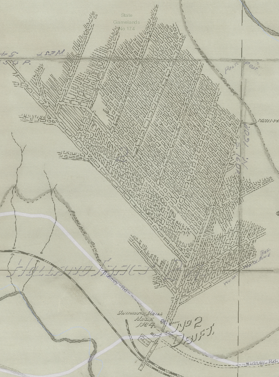
A 1906 topo map shows one building at Sidney, which appears to be the school. Keal Run is not shown, and the road between the two is not shown.
I eventually found a history of Banks Township dated 1913 ![]() which says the area was mostly logging in prior years, but transitioning to coal mining.
which says the area was mostly logging in prior years, but transitioning to coal mining.
It says a schoolhouse was there for 4 years during the logging boom but then moved, which fits with the 1906 topo map.
The 1906 map shows railroad through Sidney to Hillman and onwards to Punxsy, and another branch coming north to end at nearby Urey.
Timber and Sawmilling
The 1913 history mentions Graham’s tract “…by far the most valuable timber land in Indiana county…” while a 1914 mining map shows (James) Graham’s Mill and a millpond on Sidney Road near Lochvale. Thus it would appear it was a sawmill.
In 1870 the vicinity north of Bear Run was called “The Wilderness,”
Banks Township History
The history says timber was mostly white pine, floated to Williamsport. Hemlock was sawn for fence boards and hauled by wagon to Indiana (a 2 day trip). Graham must have been quite happy when railroad was extended to his mill!
Graham’s may have also been a gristmill, as farming is mentioned in the 1913 history. It’s hard to imagine farming successfully in this area, but some people were trying it. The northern part of the township is said to contain “some of the best farms and most prosperous farmers in Indiana county”, which is perhaps an informative statement about farming conditions in other parts of the county!
The 1906 topo map shows the road from Lochvale to Graham’s Mill, with several buildings and the millpond illustrated.
The area of the mill appears it was strip mined, so any traces of the mill or pond are probably gone.
Early Coal
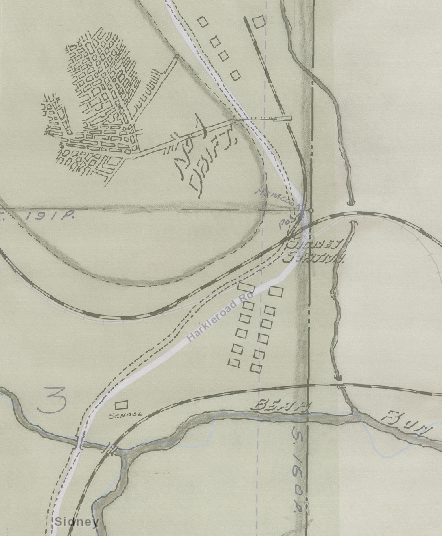
After the timber was consumed, coal mining took over. A 1914 mining map from Bear Run Coal & Coke shows two drifts (horizontal mine entrances) near Sidney. The township history mentions mining there, and also the railroad to a mine at Urey.
The mine map shows a village at Sidney, including the school. A railroad station is marked.
A lot of the land is marked as “Holland Tract”. A search on that leads to interesting history ![]() of how considerable land in Jefferson county was owned by wealthy Dutch, who loaned money for the Revolutionary War and took land in New York and Pennsylvania as collateral!
of how considerable land in Jefferson county was owned by wealthy Dutch, who loaned money for the Revolutionary War and took land in New York and Pennsylvania as collateral!
The founder of Bear Run Coal & Coke was Thomas Taylor Boswell, for whom the mining town of Boswell (Somerset county) is named. Company headquarters were in Baltimore, and rather curiously, he lived in the neighborhood where I grew up.
Prior to Bear Run, Boswell founded Merchants’ Coal Company, which built quite a company town and large mine at Boswell. Merchants eventually belonged to massive Hillman Coal of Pittsburgh. It seems likely that the village “Hillman” north of Sidney is not coincidence, though it seems way out of the operating area for Hillman Coal.
It’s interesting to ponder whether Boswell thought Sidney might someday look like the town that bears his name, with rows of substantial brick and stone houses, multiple stores, and a massive tipple producing 3000 tons a day! Boswell is still a town today, whereas Sidney seems to have been gone by 1940.
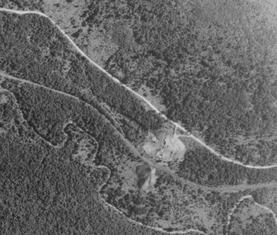
USGS LIDAR shows clear evidence of Sidney’s main street and houses. The collapsed entrance for #1 Drift mine shows up clearly on LIDAR along the road north of the village.
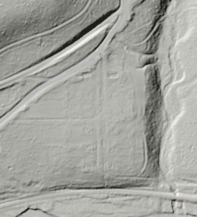
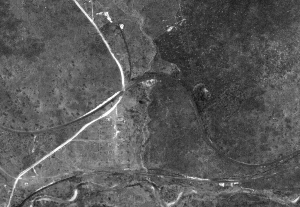
Compare the LIDAR view with an aerial photo from 1940 from Pennpilot. It appears all the houses are gone. The foundation of the school is quite visible. This aerial seems to show no evidence that there was ever a brick yard (discussed later).
It doesn’t seem like #1 mine at Sidney was ever very large. The 1914 map certainly doesn’t show it as much (see above map). The 1907 state report lists only 8 miners and 35 total underground employees, not much labor for a coal mine of that era.
Railroad at Sidney and Keal Run
The railroad is marked Pennsylvania Railroad, Bellwood Division, which means this was considered an extension of the Bell’s Gap Railroad (originally narrow gauge), which started in Bellwood (north of Altoona) where the Bell’s Gap Rail Trail is. The connection between the two is certainly not a direct route!
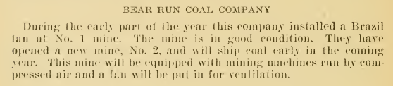
#2 Drift Mine
A 1907 state mining report gives insight into the creation of #2 Drift mine…
Between Sidney and Keal Run, the 1914 mine map shows the fairly extensive #2 Drift mine, many times larger than #1 mine.
Underground workings at #2 Drift were extensive room and pillar mining ![]() . Based on the early dates of these mines, coal was almost certainly hauled out by mules, although the 1907 report claims they were mechanizing! Of course the mules probably did all the work to build the electric haulage…
. Based on the early dates of these mines, coal was almost certainly hauled out by mules, although the 1907 report claims they were mechanizing! Of course the mules probably did all the work to build the electric haulage…
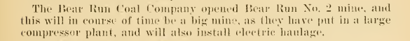
That’s a lot of work for those poor animals. Of course the miners didn’t have it a whole lot better! We are working on a page recognizing the contributions of mine mules.
Because these were drift (horizontal) mines without elevators, mules were probably stabled outside. At least they got some time outside and may have gotten to run and roll, but their lives were surely not very long. If the mule barn locations were mapped, I’d be out looking for a mule shoe.
The 1914 mine map shows a power house, fan, and tipple at #2 Drift, on what would become the railroad to Lochvale (Bear Run branch). I think I saw the collapsed entrance of this mine when driving the road.
Keal Run
The 1914 mine map shows “prospect drift #2” near Keal Run, but that’s all.
After I initially wrote this page I found a 1939 aerial view which shows a decent cluster of houses at Keal Run. A mine waste dump is visible at the north end of the village, and a path from the town to what must have been the mine portal. It appears there is a railroad spur toward the mine dump, but mining may have ceased by this time. It appears Keal Run remained a village a bit longer than Sidney, since Sidney’s houses all appear gone by this date.
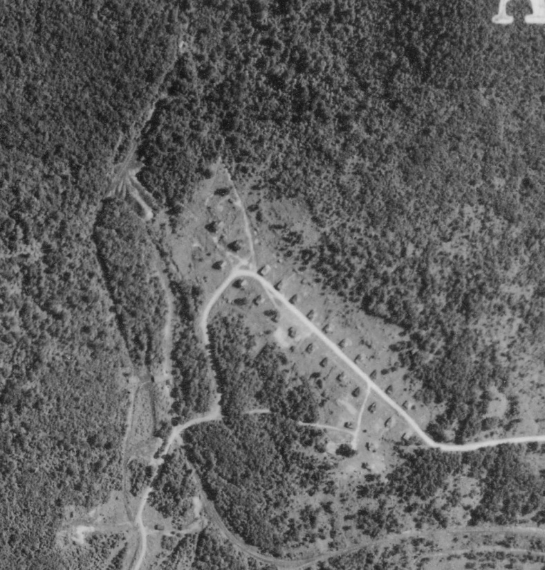
Current USGS maps show one structure remained at Keal Run fairly late, but it’s hard to tell what it was. Maybe one house held out long after the rest were gone.
Lochvale
The 1913 history mentions Superior Coal near Lochvale, and a 1920 mine map shows Superior #1, Superior #2, Superior #3, and Superior #4 mine portals near the intersection of Sidney Road and Lochvale Road. The surface appears to have been strip mined in later years (probably to retrieve coal left in pillars), so any evidence of the drift mines is probably gone.
A 1967 map of Friel-Marshall Coal Mining Company shows extensive room and pillar mining completed a bit to the west of Lochvale and called Bear Run Mine. They sure weren’t very creative with names! This map was probably in preparation for stripping, as no active portals are shown. This mine is probably what’s shown on “modern” USGS topo maps with a mine conveyor (removed during reclamation).
A Johnstown Coal & Coke mining map shows Bear Run #2 Mine just to the south west of the intersection of Sidney and Lochvale Roads. It also shows the abandoned Superior #3 portal. An extensive area of room and pillar mining is shown. The date is blank.
If the west branch of Bear Run wasn’t already destroyed by Acid Mine Drainage ![]() , strip mining these areas sure took care of it.
, strip mining these areas sure took care of it.
Other Mining
Other coal mining probably took place in the area, especially strip mining in later years. It’s unclear when the state acquired SGL 174. Deep and strip mining around Lochvale seem to have continued after the creation of SGL 174 around Sidney and Keal Run. The area south of Lochvale appears to have been added to the SGL later.
A rather extensive mine reclamation project has been done west of Lochvale at the former Johnstown Coal & Coke mine. A number of areas around Sidney and Keal Run have obviously been reclaimed. Aerial views (2023) suggest Sidney’s Drift #2 entrance was only recently reclaimed.
Some aerial views in 2023 show active mining south of Lockvale at the intersection of Lockvale Road and Fire Tower Road, so this must have been completed and reclaimed quite recently.
Bricks
A 1921 map shows Burton Clay Products of Altoona planned a brick plant at Sidney. The map shows several old clay workings, an “old tram road” and several coal tipples. Three locations were being evaluated for the brick plant and they are shown with beehive kilns.
Fire clay is often found adjacent to coal, so it’s not surprising they were thinking about a brick plant here. These would have been refractory bricks (“fire bricks”) for lining furnaces at iron and steel works, not building bricks. Unfortunately their timing was poor. If the plant was ever built, it probably succumbed to the Great Depression. LIDAR and the 1940 aerial views of Sidney don’t seem to show evidence any brick plant was ever built.
Personal Connections?
If you have any stories about the history of these towns–maybe your parents or grandparents lived there?–we’d like to hear from you.
updated 3/2024 with aerial views