We have mapped a huge number of public horse riding trails and even some horse driving trails for Pennsylvania and surrounding states in OpenStreetMap.
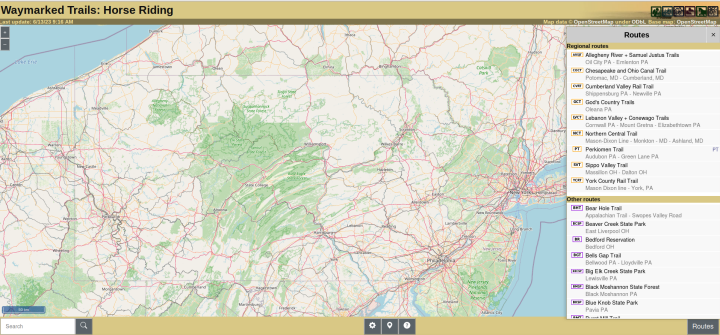
An overview of trails can easily be viewed using Waymarked Trails…
or check out our post on a New Horse Mapping Tool!
In Waymarked Trails, click on the [Routes] button at lower right and zoom in and out to vary the trails shown. No trails may show if you are zoomed out! Click on a specific trail to get additional details. You can download a file of the trails to view in your favorite map app.
We have added:
- Pennsylvania rail trails allowing horses on more than a few miles
- Pennsylvania state parks with significant horse trails
- State Game Lands with designated trails of more than a few miles
- urban/suburban local and county parks with horse trails
- hundreds and hundreds of Pennsylvania state forest trails
We believe this is probably the most comprehensive map of public riding trails for Pennsylvania–period! We also added maps in bordering states Maryland, Ohio, New York, West Virginia, Virginia and Delaware, and a few horse driving trails.
All of this is free and open data, no signing up for anything, no monthly fees. You can download a network of trails or a single trail to your phone or GPS for free (using gpx and kml download links).
Other Ways to Map Horse Trails
As mentioned above, check out our post on a FREE New Horse Mapping Tool (gpx.studio) which allows you to click and drag to construct a custom route with distance, elevation profile, and multiple views like topo and aerial view.
You can also see our trail data in OpenStreetMap, but it’s hard to locate trails specifically open to horse use:
Create your own routes and maps showing distances, slopes, elevation using free sites like:
There is no “horse” mode, but setting it for hiking mode works fairly well.
Contribute Your Favorite Trails
You can help! Let us know if there are trails you ride that should be included, or join the OpenStreetMap project (it’s free) and help the riding community by adding trails yourself.
One of the great things about OpenStreetMap is their data is used by literally hundreds of other mapping apps (or can be turned on as a basemap), so trails put in OSM show up many other places.