
Summary
Wild and remote, Quehanna offers many miles of trails on a high plateau, with the opportunity to see herds of elk. Facilities are scarce, parking options are limited, and food and fuel are distant. Horse campground, but with minimal facilities.
Quehanna Wild Area is the largest area of its type in Pennsylvania, with over 50,000 acres of relative wilderness, just an hour from State College.
We have visited Quehanna a few times in 2024 and 2025 and every trail has been a pleasure. We have trail pictures we hope to get on here, if we can just find time to add them!
Trail Overview Map
Use Waymarked Trails: Quehanna![]() to view all horse trails around Quehanna Wild Area. You can download them to your navigation device.
to view all horse trails around Quehanna Wild Area. You can download them to your navigation device.

We also have a new way you can explore the horse trails – Gpx.Studio
Read on for horse trailer parking options and much more information.
There May Be Elk!
If you’re not from the area, you may not know that Quehanna is elk country. And if you’re not from elk country, your horse may not know what elk are! So be prepared for a surprise.
On our first visit to Quehanna, our horse went on major alert after spotting a bunch of ratty looking elk off in the woods. Major curiosity! Eventually the elk wandered off, but several other times on our ride he stopped and pointed out to me that those smelly things were out there… waiting. Watching.
Riding in Hunting Seasons
In October 2025, the area seems to have almost no recreational users, which may be due to new 7 day hunting. We’ve visited several times and really aren’t worried about hunters. We saw just a few archery hunters, and heard one gun shot all afternoon during early rifle season. The area is so big that hunter density (other than main deer season after Thanksgiving) is very low.
If you wear your hi-viz colors, ride in groups, stay on marked trails, and avoid cold mornings, we believe fall hunting should not prevent you from visiting Quehanna.
A Feel for the Area
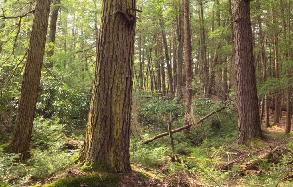
Quehanna is a plateau about 2000 feet above sea level. The area was extensively clear cut during logging railroad days. Due to cold climate and poor soil, trees regrow slowly. While some areas are densely wooded, others remain somewhat sketchy and thinly wooded. For the most part, don’t expect massive towering oaks in the region.
Because of the elevation, expect temperatures to be cooler than surrounding areas, and winds to probably be higher.

Trail Details
As we explore more in 2025 we will add details and photos of trails at Quehanna.
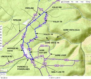
Gore Loop
A relatively short loop off Baily Log, this trail is a wide woods track with mostly dirt footing with a few scattered rocks. Some areas are grassy. The woods to the west is largely uniform young growth (larches?) and a little boring. To the east the trail becomes a little more hilly, and the woods a bit more mature and varied. Grade A– for the few rocks.
Baily Log Trail
This easy and beautiful trail is a wide woods track, always wider than single file. Many areas are grassy, others are dirt with some scattered rocks. A few areas can be damp at times. Woods are varied, from relatively thin to dense Mountain Laurel patches, with a few stands of pine thrown in. Some areas are a little sunny. One modest hill at the south end as it comes out onto Old Wykoff Run road, otherwise level. Grade A– for the few rocks.
Gore Cutoff Trail
Fairly easy wide woods path is grass and dirt through mature forest. The southern end along the former airfield is a bit rough and uneven, with scattered rocks, ruts, dips. The north end is much smoother. Note the many huge tree stumps remaining 120 years after the logging railroad era! Grade B because of the rough areas.
Gore Draft Road (Powerline Loop Trail)
Very wide and easy woods road (signed as Powerline Loop Trail at Old Wykoff Run road). We haven’t covered the entire distance yet but it looks mostly easy. A ranger told us the part of Powerline Loop Trail along the powerlines gets fairly rocky at the east end towards the vista. Grade A for Gore Draft road, maybe B-C for the powerline.
Foley Trail
Wow! Maybe our new favorite trail in the area. Beautiful and just a little challenging, this path varies from a wide woods path to a narrow singletrack as it winds through varied terrain. Most is mature woods but there are a few patches of pines and several open areas with sunlight. Dirt with a little grass in most areas. Footing is a little tricky in places, with some roughness, a few big rocks to step around, and a handful of downed trees to bypass. It’s not flat, but grades are relatively minor. There is one wooden bridge across a swampy area, which can be bypassed in dry weather. Brush and branches are cut back well. Blazes freshly painted in November 2025. Grade B- because of challenging surfaces.
Gore Vista Trail
We haven’t covered the entire trail but to Gore Cutoff and Foley Trail it appears to be very easy wide woods path, mostly grass and dirt, through mature woods. Good footing in most areas; a few rocky spots. Minor grades. Blazes freshly painted in November 2025. Brush is good. Grade A-.
Mohawk Trail
An easy ride. Beautiful two-track forest road with mix of small rocks, dirt, and shale. Lots of grass. Road winds through mixed woods with a few dips. Some slopes may be washed and have coarser stone for short distances. A few wet spots, especially around streams (which pass through culverts). Accessible from Yellowsnake camping by riding wide shoulder of highway a short distance. Grade A.
Cole Run Trail
Short connector trail is a wide single-track with a mix of small stones and dirt. Parts are grassy. Somewhat open woods with nice views. Grade B.
Erie Camp Trail
Beautiful woods. Single track on a former woods road. Mix of small rocks, dirt, and shale. Rocks tend to be small and rounded, though there are some big slabs of embedded rock at places. Lots of grassy areas, especially nearer highway. Short cut-over next to highway seems quite muddy; you may want to ride shoulder of highway instead, though it’s not exactly dry either! Grade B.
East of highway, trail is surfaced with fine gravel due to traffic near Yellowsnake campground. Grade A.
Ligament Trail
An easy, wide single-track trail through mature woods, with a few more open areas. A few rocks, but generally dirt or grass. We haven’t covered all of the north leg to Wykoff Run road but do know there are two very substantial bridges crossing the stream there… no problems crossing with horses. Grade B because it may be a little rougher in the north end.
Bellefonte Posse Trail
Two-track woods road is surfaced with coarse stone for maybe 1/2 mile off the highway. When it gets deeper into the woods it gets a little vague at times. It’s also confusing because it makes several turns! We actually ended up going out Panther Run trail to Chipper road, so we didn’t cover the entire trail. Grade B for coarse stone.
Twister Trail
Nothing very exciting, just winds along the highway and connects #11 trail and Ligament trail. Easy, wide, some areas are coarse stone, some are dirt and grass. Grade B for coarse stone areas.
Chipper Road
Two-track woods road is an easy ride through woods. Some mature woods, some pine plantations. A few damp spots. Grade A
Pipeline Trail
The areas of the pipelines we have ridden have two-track paths which are dirt and grass with a few small rocks mixed in. There is generally lots of grass along the trail. Lots of birds to see. Can be pretty sunny. Not super exciting, but not bad for connecting other trails.
General Trail Notes
Most trails are naturally dirt or sand with some small rocks mixed in. Rocks tend to be rounded. We have seen some trails surfaced with coarse gravel (think railroad ballast) in places. Bellefonte Posse is this way for at least 1/2 mile off Quehanna Hwy. Part of the short #11 Connector is similar. If you have tender feet, these areas may not be good for you.
In general, Quehanna is probably best ridden with at least front shoes or boots. If your horse is very tender-footed, Quehanna may not be the best place to ride.
The trails we’ve visited are fairly easy, with modest grades and reasonable footing. Some of the more remote trails (part of long loops) may be quite rocky due to the nature of the area.
Trail Heads
The following photos give you an idea of some of the horse-riding trail heads at Quehanna Wild Area. We’ll try to add more trail photos in 2025!


Quehanna Highway
The shoulder of Quehanna Highway is wide enough to safely ride in many places, but gets overgrown in summertime. It does not appear they mow it in summer, although some areas get tramped down. It seems to get mowed down in October, making it nice fall riding.
There are many places you could pull off a horse trailer along the highway. Just check for swampy spots, as the nearest tow truck is a long ways away.

West End
Hoover Road northwest of Lincoln Road is a sandy township road which can be ridden but which also gives access to several large pipeline right of ways with plenty of space for parking horse trailers. Signs at these spots indicate that horse riding on the pipelines is permitted. The sandy road can be quite hard when weather stays dry, and fairly squishy when the weather has been wet!

For two miles from Lincoln Road, the road is pretty good. Beyond the second pipeline crossing, road surface deteriorates significantly. You probably don’t want to continue with a horse trailer, especially if the weather has been wet.

Horse Loop Trails from Yellowsnake
Yellowsnake campground and the adjacent day-use parking is a good starting point for several loops in the east end. Most loop options from here are pretty long.
Name | Miles | Time | Vertical | Description | Map Link |
|---|---|---|---|---|---|
| Loop Y1 | 4.8 | 1:35 | 320 | Yellowsnake – Erie Camp – Cole Run – Mohawk | Map |
| Piper Loop | 9.4 | 850 | Mohawk – Middle Ridge – Fisher – Black Powder | ||
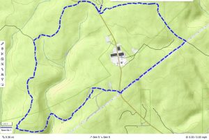
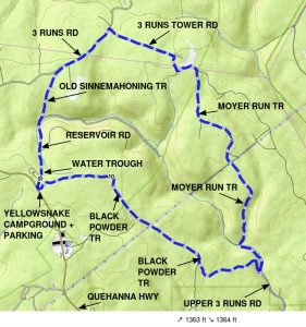
| Moyer Run Loop | 11.2 | 1360 | Reservoir – Sinnemahoning – 3 Runs – 3 Runs Tower – Moyer Run – Black Powder |
Loop Y1 – Quehanna Sampler
This trail is an easy but scenic loop from Yellowsnake Campground or adjacent day-use parking. Mostly wooded, good footing, not much vertical. One of the few short loops in the east end. A wonderful introduction to Quehanna!

Piper Loop
9.4 mile loop encircles the village of Piper (Quehanna Boot Camp). Climbing east of Cole Run includes a half mile of 8.5% average grade, with spots over 15%. The direction shown has a long climb back to Yellowsnake camp; you might consider riding this clockwise instead if you don’t mind the steep descent to Cole Run. Between Mohawk Trail and Yellowsnake involves riding along the (wide) grass shoulder of Quehanna Highway.

Moyer Run Loop
This 11.3 mile loop includes a grueling 1360 feet of elevation change as it descends ito Upper Three Runs then climbs back to the plateau. You probably won’t bump into us doing this loop, but have fun!

Horse Loop Trails from Wykoff Run
Here are a few horse riding loop trails starting from Wykoff Run Road near Hoover Farm wildlife viewing area. These are in the central part of Quehanna.
| Name | Miles | Time | Vertical | Description | Map Link |
|---|---|---|---|---|---|
| Loop W1 | 5.5 | 1:50 | 245 | Wykoff – Ligament – Twister – 11 – 11 Conn – Chipper Rd – Bellefonte Posse – Ligament – Wykoff | Map |
| Loop W2 | 6.2 | 2:00 | 460 | Wykoff – Ligament – Baily Log – Hoover Rd – Old Wykoff Run Rd – Ligament – Wykoff | Map |
| Loop W3 | 7.4 | 2:30 | 530 | Wykoff – Ligament – Baily Log – Gore Loop – Baily Log – Hoover Rd – Old Wykoff Run Rd – Ligament – Wykoff | Map |
We now have printable maps of these loops…
Loop W1
5.5 miles

Loop W2
6.2 miles. Returns on Old Wykoff Run Road, which is gravel.

Loop W3
7.4 miles. Fair distance on Old Wykoff Run Road, which is gravel.

Horse Riding Loops from Hoover Road
These loop trails start on Hoover Road near Lincoln Road, where there is reasonable parking under powerlines. These get you out towards the northern end of trails at Quehanna. Trails in this area seem very pleasant, and there are more options for 1-3 hour loops.
| Name | Miles | Time | Vertical | Description | Map Link |
|---|---|---|---|---|---|
| Loop H0 | 5.0 | 1:45 | 310 | Baily Log – Gore Loop – Powerline Loop – Gore Draft Rd – Old Wykoff Run Rd – Hoover Rd | |
| Loop H1 | 5.8 | 1:55 | 370 | Baily Log – Gore Loop – Powerline Loop – Gore Draft Rd – Old Wykoff Run Rd – Hoover Rd | |
| Loop H2 | 7.3 | 2:30 | 440 | Hoover Rd – Gore Vista Rd – Gore Cutoff – Baily Log – Gore Loop – Powerline Loop – Gore Draft Rd – Old Wykoff Run Rd – Hoover Rd |
Loop H0
5 miles. Park under powerlines on Hoover Road and ride to overlook of Wykoff Run, but with minimal detours. Short distance on Old Wykoff Run Road, which is gravel. Only about 300 feet of vertical. Section along powerline may be a bit rocky.
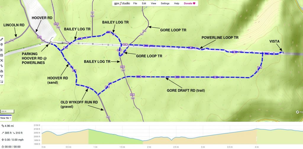
Loop H1
5.8 miles. Ride out to a vista overlooking Wykoff Run gorge, by way of Gore Loop. Section along powerline may be a bit rocky. (The vista is not “Gore Vista”, which is farther north)

Loop H2
7.3 miles. Slightly longer version of above, loops around former airfield. Hoover Road along the airfield is sand and great footing, but it is a road. (The vista is not “Gore Vista”, which is farther north)

Loop H3
5.3 miles. An easy loop around the old airfield and over part of the pipeline. Very little vertical. Considerable distance on Hoover Road, a township road which is sand and easy riding.
Supplies
Be warned, there is very little in the region! Plan on bringing food, drinks, and plenty of fuel.
Benton’s Market is a small general store in Karthaus, which closes at 2pm on Saturday, 1pm on Sunday (kitchen closes 30 minutes before store). They make tasty, inexpensive sandwiches and have limited hot food. No fuel. Restroom. Limited parking, though you can go around block and park on side street. (Oct 2025)
Quehanna Lodge Bar and Grill ![]() looks like a reasonable place for food. It’s on Quehanna highway just north of Rt 879 intersection near Karthaus. Hours are Fri-Sun 12-9 (Oct 2025), but they seem to change often! Plenty of parking.
looks like a reasonable place for food. It’s on Quehanna highway just north of Rt 879 intersection near Karthaus. Hours are Fri-Sun 12-9 (Oct 2025), but they seem to change often! Plenty of parking.
Friday’s self-service fueling station in Karthaus takes credit cards only but has gas and diesel. Open 24/7.
Your next food options are Benezette or Snow Shoe, neither of which are very close; online reviews of food options in Medix Run and Benezette are not inspiring!
Brothers Pizza in Snow Shoe is decent, though the staff could use an attitude adjustment 🙂 CLOSED on Sunday.
[closed for season, Oct 2025] Sweet Dream’s ice cream stand in Snow Shoe is open in summer, 5-9 Thursday/Friday, 1-9 Saturday/Sunday. No food, just ice cream. Hershey’s ice cream! Limited parking.
Facilities
There are pit toilets at Hoover Farm Wildlife Viewing parking lot at Quehanna Pike and Wykoff Run Road, but they are CLOSED “out of season”. Space is limited to pull in a rig here, but there is a gravel parking area on Wykoff a short distance across the highway. There are unfortunately NO other restrooms anywhere in the area!
Not sure who comes up with the idea of “in season”–in March 2024 we visited and it was 60F; in March 2025 it was 70 and there were a lot of visitors–and no bathrooms.
There are NO restrooms at Yellowsnake campground. In order to camp there, you must have a trailer with a self-contained toilet. The only restrooms in the entire wild area are at Hoover Farm Wildlife Viewing, and closed in winter.
The forest office farther west on Quehanna Highway probably does not have public restrooms, and it doesn’t seem to be open weekends.
One would think Pennsylvania could do a bit more than this in a major recreational area.
Horse Camping
Yellowsnake Equestrian Campground has six sites which are available by reservation. So get this: the reservation website says it’s strictly equestrian camping only (in bold!). Then it says it’s only open to equestrian users Memorial Day through October 31, horses are forbidden outside that range. So which is it? I can see opening it to other users over the winter, but why in the world would horses be forbidden then? Pennsylvania’s public information and policies are just sad.
Each site has standing stalls. Design varies between sites and some may not be suitable for larger horses. Sites 3 and 4 have two larger standing stalls suitable for big horses. The other sites have 4 stalls which aren’t very big.


Yellowsnake campground has NO restrooms. NO running water. You must have a self-contained trailer (i.e. toilet) in order to camp here. There is a central manure pit.
Why this campground is only open Memorial Day through October 31 is baffling. November, April and May are ideal riding months, and we often get out all year long. In mid-March 2024 it was 60 degrees there, and in late March 2025 it was 70! In late October 2025 it was in the upper 70s. Maybe the state needs a reality check on their recreational calendar?
Horse Water Sources
Yellowsnake Horse Camping area at Quehanna Highway and Reservoir Road has a spring-fed watering trough. You can use this for horses even if you are not camping there. It is on Reservoir Road right outside the campground. A sign says the water is not tested, although several locals have told us they take it for home use.

No other public water sources are known, so bring at least a minimal supply of water for you and your horse when you are in this area. There are some streams but they can be tricky to reach.
Horse Trailer Parking
Considering all the miles of trails, there really aren’t great horse trailer parking options at Quehanna Wild Area. Be warned, most parking areas marked on DCNR maps are NOT big enough for horse trailers.
Unfortunately Pennsylvania seems to have little interest in making parks or forests welcoming for horse riders.
Reservoir Road at Quehanna Highway is “designated” day-use horse trailer parking near Yellowsnake campground. It could hold a few trailers but it’s mostly just a grass clearing–with obstacles in it! Parts of it are often quite swampy. There is usually some grass for grazing. It is right next to the highway; brilliant idea. Pretty sad they can’t provide a legitimate day-use lot someplace, maybe one that’s not a swamp, and perhaps with a porta-pot!
This spot has an information board which should have printed maps of the trails.


Wykoff Run at Quehanna Highway is parking for Hoover Farm Wildlife Viewing area. On an off season weekday you might be able to park a horse trailer there to access trails farther west away from Yellowsnake camping area, but it is a small lot and you may piss off wildlife lookers.

A small gravel lot nearby on Wykoff Run Road may be open at slow times. In nicer weather it’s often filled with hikers going to the “bat bunkers” but we’ve been there on beautiful days when it’s empty.

Lincoln Road just off Quehanna Highway has a parking area which might hold one small trailer, but it does seem to get hikers.

Informal Parking
Since the state can’t be bothered to create legitimate trailer parking, you often have to hunt up the best spot you can. Some suggestions are…
Number 11 Connector at Quehanna Highway has a parking area, but it seems very popular with hikers. When we visited in late March there was no room for a horse trailer! It is right on the highway.

Number 11 Trail at Quehanna Highway has a pulloff loop that would hold a couple trailers, giving access to #11 and Twister Trail. It is right on the highway.

Three Runs Road at Quehanna Highway has a pulloff that could hold a couple small trailers, getting you indirectly to Number 11 and Old Sinnemahoning Trails (via Three Runs Road). It’s right on the highway.

Ligament Trail at Quehanna Highway has enough room to pull in one trailer, and it’s an easy trail through pleasant woods which gives access to Twister Trail, Chipper Road, and Old Wykoff Run road.

Hoover Road just south of Lincoln Road has an area under power lines big enough to hold a couple trailers on either side of the road. This gives access to trails farther west in Quehanna. One side is a bit rough and sometimes very muddy. Ironically, there is a former airfield right next to it where the state could develop a proper trailer parking area, but…? The airfield does offer lots of grass for your horses, even after prolonged dry weather!


Lincoln Road just before Hoover Road has a wide grassy shoulder along the Noble-Chambers Memorial Forest. Noble and Chambers probably wouldn’t mind some company, and you could easily fit several trailers there. Not sure how well drained it is in wet weather.


Hoover Road is in pretty good shape for about 2 miles northwest of Lincoln Road, which gives access to several large clearings at two underground pipelines. You probably don’t want to go past the second pipeline, as the road gets pretty rough and swampy!


Hoover Road at Gore Vista Trail has a small parking area where you could pull in one trailer and get access to trails in the north end.
We suggest you talk to any rangers you see about the lack of parking, and consider contacting the newly-created Pennsylvania “Office of Outdoor Recreation” ![]() and tell them you would like better horse trailer parking (and maybe a bathroom or two) in state lands with horse trails. The squeaky horse gets the grease!
and tell them you would like better horse trailer parking (and maybe a bathroom or two) in state lands with horse trails. The squeaky horse gets the grease!