Summary
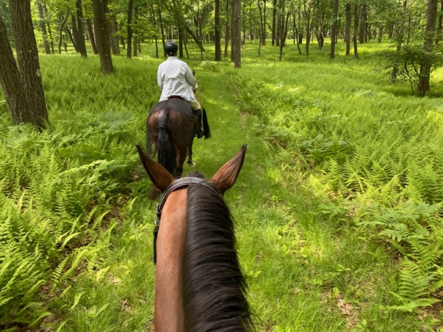
Beautiful, secluded park offers a significant number of trails with varied woods and open areas. One of our favorite outings! Grades are reasonable and most trails offer good footing. Plenty of parking, but only in two locations. No amenities beyond picnic tables, and not much close by for food or fuel.
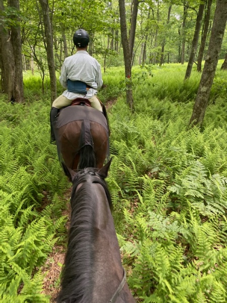
If you’re looking for horse riding trails or horse driving trails at Black Moshannon State Park and Moshannon State Forest, we have horse trail information which may be useful. We now have pictures of some of the trails too! We ride here quite often and will probably add more info in 2025.
Bugs!
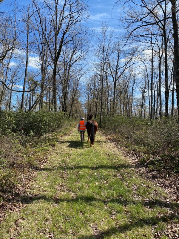
While usually we haven’t had much problems with insects at BlackMo, we did have one visit in mid-October where we pulled 30+ ticks off a horse’s legs right in the parking area on Benner Run! We suggest you carefully check yourself and your animals after any visit.
In fall you may want to spray legs with a strong (permethrin) insect repellent just to be safe.
Trails Overview
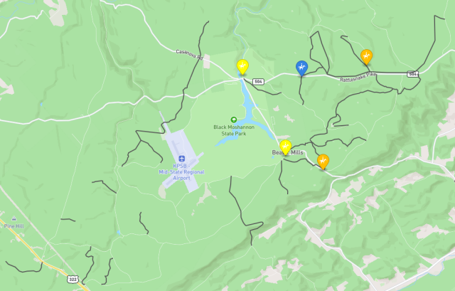
This aerial image from Gpx.Studio gives an idea of most of the horse trails around Black Moshannon park and shows that virtually everything is wooded.
See our New Horse Mapping Tool post for more info.

Mapbox Experiments
We used Mapbox to create a live “slippy” map of horse riding trails and horse driving trails around Black Moshannon.
GeoJson Map – Black Moshannon area ![]()
The new map shows color coded horse trailer parking:
![]() official horse trailer parking
official horse trailer parking
![]() horse trailers fit, best for off-peak/off-season use
horse trailers fit, best for off-peak/off-season use
![]() may be usable but not ideal (small, tight access, noise, etc.)
may be usable but not ideal (small, tight access, noise, etc.)
Other Maps
The Moshannon State Forest office ![]() does have a paper horseback riding map they give out if you visit the office. It was updated in 2023 but they still seem to be giving out the old one! It shows trails but also includes a lot of gravel roads that can be ridden, and it doesn’t distinguish between them! Trails which are closed to vehicles are more scenic and much better footing than the compacted stone on roads.
does have a paper horseback riding map they give out if you visit the office. It was updated in 2023 but they still seem to be giving out the old one! It shows trails but also includes a lot of gravel roads that can be ridden, and it doesn’t distinguish between them! Trails which are closed to vehicles are more scenic and much better footing than the compacted stone on roads.
Loop Trails
We’ve mapped a number of horse trail routes you might find helpful, trying for loops to keep things interesting for you and your horse.
After talking with riders using our maps of BlackMo we are adding map images you can just print and go; these have BIGGER TEXT for reading on horseback!
View live Graphhopper maps of these routes if you want to modify the route. From the live map you can also download a GPX track of the route to follow with your navigation device.
Riding from Benner Run
Just off Rt 504 (Rattlesnake Pike), this large lot is the main equestrian day-use parking and a great starting point for many horse riding options.
All trails involved are pretty easy horse riding. Road sections are gravel with very little traffic, just not as scenic as dedicated trails.
Loops mostly give a cool-down ending on Ridge Trail, which is fairly level.
Peeking Duck Loop
| Distance | Time | Vertical | Route or Nickname | Live map |
|---|---|---|---|---|
| 4.7 miles | 1:35 | 515 feet | POA-Benner (1.2m road)-NorthRun-Ridge | Link |

Ghost Loop
| Distance | Time | Vertical | Route or Nickname | Live map |
|---|---|---|---|---|
| 5.0 miles | 1:40 | 560 feet | POA-Benner (1.2m road)-Rattlesnake-Ridge | Link |

Big Tee Loop
This loop uses part of a pipeline right-of-way which doesn’t seem to be an official trail. Parts we have covered are in pretty good shape, but expect some branches to dodge.
| Distance | Time | Vertical | Route or Nickname | Live map |
|---|---|---|---|---|
| 6.1 miles | 2:00 | 625 feet | SmaysRun-NorthRun (trail+0.9m road)-Underwood (road)-StageCoach-Ridge | Link |

Leaning Loop of Italy
Probably the most popular horse riding loop at BlackMo, this covers many of the major trails in the northern region. Short distance on North Run Road, but the gravel is actually worse on North Run trail than on the road!
| Distance | Time | Vertical | Route or Nickname | Live map |
|---|---|---|---|---|
| 8.5 miles | 2:53 | 1050 feet | Ridge-NorthRun (trail+0.9m road)-Smays-StageCoach-Ridge | Link |

Whale Loop
This short loop is a great way to have a quick ride in peaceful and beautiful woods at BlackMo. We do this loop frequently!
| Distance | Time | Vertical | Route or Nickname | Live map |
|---|---|---|---|---|
| 3.6 miles | 1:11 | 310 feet | SmaysTrail-StageCoach-Ridge | Link |

Fallen Duck Loop
Maybe the second most popular loop at BlackMo, a slightly shorter version of Leaning Loop of Italy (above). Short distance on North Run Road, but the gravel is actually worse on North Run trail than on the road! North Run does involve a bit of a climb going south to Route 504.
| Distance | Time | Vertical | Route or Nickname | Live map |
|---|---|---|---|---|
| 6.9 miles | 2:18 | 680 feet | Ridge-NorthRun (trail+0.9m road)-Smays-Ridge | Link |

Short Loops
Here are a couple “lollipop” loops that share start and end segments but have a loop at the end…
| Distance | Time | Vertical | Route or Nickname | Live map |
|---|---|---|---|---|
| 3.6 | 1:11 | 388 feet | “North Run Lasso” (parking North Run Trail at 504) North Run Trail-Rattlesnake Trail | Link |
| 5.0 miles | 1:40 | 560 feet | “Benner Lasso” (parking at Benner Run lot) POA-Ridge-Rattlesnake-North Run-Ridge-POA | Link |
Benner Lasso Loop
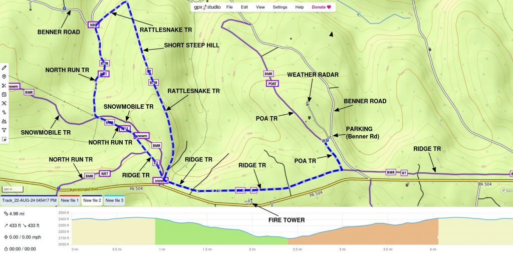
Easy 5 mile loop may be ridden or driven (no gates). Either North Run trail or Snowmobile trail may be used at southwest corner. Short, steep climb on Rattlesnake trail going in suggested direction, otherwise grades are all modest. Parts of North Run and most of Ridge trail have a gravel base under grass. Rattlesnake is mostly dirt/grass. Note that parking is on Benner Run Road.
Riding from Mid-State Airport
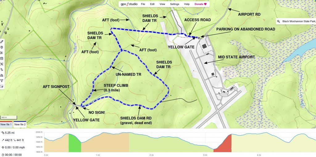
In fall 2025 we explored some trails in the west of the region, around Mid-State Airport.
Airport Loop 1
Enjoyable 5.3 mile loop starts from parking on a stretch of abandoned roadway just before the airport. Has some steep hills but generally easy other than some irritatingly-long gravel stretches. Very peaceful unless there is an event at the airport!
A gated access road takes you to Shields Dam trail. Shields Dam trail passes through lovely meadows then enters woods as dirt/sand/moss two-track forest road on a former powerline right of way. It has several short but quite steep hills. At the fishhook turn at the west end the trail surface unfortunately changes to fairly coarse gravel (#2).
After passing the AFT signs, stay to your left on Shields Dam trail. Gravel continues most of the way until you reach a cabin and Shields Dam road. Turn right on the road (it dead ends at a camp and traffic is unlikely) and continue west. The road is gravel, but it’s finer stone than the trail. Shortly before the Six Mile Run bridge, take a right on an un-marked grass/dirt trail. If you come to an AFT signpost or yellow gate, you just missed your turn! Some maps show a stream ford at this junction, but that is incorrect.
The un-named trail climbs up the hill to complete a triangular loop. It was mowed in fall of 2025 and is in good shape, although it’s not shown on most forest maps. The first part is steep grass/dirt for about 0.3 miles as it climbs 200 feet (~11% grade). After the summit it is dirt and pine needles through a pine plantation, and eventually connects back with Shields Dam trail.
Shields Dam trail also continues north of the starting point. We rode some of it and looped back on the access road. It was all easy grass footing, with a couple significant hills.
There is plenty of parking for trailers at the start of the airport, and grass for grazing horses. The nearby airport has a small cafe open Fri-Sun for limited hours, and must have bathrooms. Nothing flew in or out during our rides; most traffic is small private planes. The airport does host “autocross” events some weekends, with roaring engines and squealing tires easily audible even well out on the trails.
Horse Driving Trails from Benner Run
If you’d like to try horse driving at Moshannon, routes are way trickier but we are working on it. Most trails are wide and smooth enough for driving your horse, but there are large rock barriers or locked gates wherever they reach a road. That makes access challenging, and it’s really hard to come up with loops. Of course you can ride your horses on these trails as well!
| Distance | Time | Vertical | Route or Nickname | Live map |
|---|---|---|---|---|
| 2.6 miles | 0:50 | 315 feet | POA trail (out and back, both directions) | Link |
| 4.8 miles | 1:40 | 462 feet | POA-Ridge-Rattlesnake-North Run-Ridge (loop) | Link |
These are decent horse driving trails which are mostly grass with reasonable rocks and plenty wide. Climbs are going to be a decent workout on grass and dirt; we suggest this route is not for unfit driving horses. There are grass clearings which are good resting points.
Benner Lasso Loop (horse driving)
See description above.
Riding from Underwood Road
A small parking lot on Beaver Road at Underwood Road gives access to horse trails farther south in the park. The lot is not very big and it is right on the road, which sometimes gets busy.
| Distance | Time | Vertical | Route or Nickname | Live map |
|---|---|---|---|---|
| 3.1 miles | 1:05 | 322 feet | Smays-AFT-Beaver Meadow “Beaver Mills Loop” | Link |
| 4.4 miles | 1:27 | 440 feet | Smays to N Run-back to AFT-AFT-Beaver Meadow “Lasso Loop” | Link |
Enjoyable short loop with modest vertical. Allegheny Front Trail is open to horse riding in this section. AFT section is quite a narrow path through ferns with some tripping hazards (rocks and roots); you will be going single file. There is one short wooden bridge with railings on that section. Other sections are easy woods roads with nice shade and good footing, very pleasant riding.
Loops of 4-5 miles are lacking in the area, so “Lasso Loop” adds distance by going out to North Run Road (near the equestrian campground) and then returning to the AFT.
Riding from the Equestrian Campground
We mapped a few horse loop trails from the campground on North Run Road. We also have the connector trail from the campground mapped into OpenStreetMap, unlike most trail mapping sites!
| Distance | Time | Vertical | Route or Nickname | Live map |
|---|---|---|---|---|
| 4.5 miles | 1:32 | 510 feet | “Campground 4.5” North Run Road (0.8m)-Underwood Road-AFT-Smays Trail-Campground Connector | Link |
| 6.1 miles | 2:02 | 530 feet | “Beaver Meadows Lasso” Campground Connector-Smays Trail-AFT-Beaver Meadow-Smays Trail-Connector | Link |
Campground 4.5 is a nice ride overall, but parts are challenging! The stretch on the road goes by quickly. Be warned that the AFT segment involved is narrow, steep, and rocky! Heading west off Underwood Road, AFT gets rockier as you go, and the climb to the next local summit is significant. In late July sunny areas are overgrown by ferns, so it’s hard to see footing, and the path is single file. Tripping is likely. There are quite a few dense areas with low branches. Once you crest that summit (nice views to the north) and begin descending towards Smays Trail the going gets much better. The trail is more sand and dirt, and the woods more mature and open. The rest is easy on woods roads and the campground connector trail.
Horse Trail Details
Benner Run road from POA to North Run/Rattlesnake is an ok connector ride of about a mile. It’s certainly not flat! During wetter weather there are some small streams along it, and there is one piped spring that probably runs most of the time. In 2023 this road was surfaced with “DSA” compacted aggregate, which makes it very hard, almost like concrete, but easier than coarse gravel.
POA Trail north from the parking area is wide and mostly grassy with some rocks mixed in to start. It falls off fairly steeply at places, maybe more fun to go north than south. There are two large grass clearings good for breaks. Either clearing has a track out to Benner Run road; both are gated. POA isn’t too shady because of the orientation and lack of large trees.
Rattlesnake Trail is similar to POA but has medium trees and should be bit shadier, at least once the leaves are out. It’s wide and mostly grassy with a few rocky areas. The climbs going south are notable; it’s certainly not a level trail. There is one grass clearing towards the north end, but no other big break spots.
North Run Trail (north) Beyond Ridge trail, North Run is similar to Rattlesnake trail and the north end of POA. Somewhat thin woods, a bit sunny on hot afternoons. Trail is wide with grass footing. An easy ride.
North Run Trail (south) South of Ridge trail, North Run unfortunately is mostly gravel with a little grass. It’s more gravel than Ridge trail. From Ridge trail to Rattlesnake Pike (504) is a bit of a climb, more than I expected, though it does have some nice mountain views to the north. South of route 504 down to North Run Road, the trail passes through relatively open areas before entering more dense woods. While not steep, it descends noticeably going south.
North Run Road The stretch of the road connecting North Run trail to Smays Run trail is possibly easier riding than North Run trail! The gravel is pushed off the tire tracks on the road, whereas the trail is largely #2 stone. It’s also possible to ride the dirt shoulder of the road in many areas.
![]() Ridge Trail is built for snowmobiles so is pretty wide. It has a lot of #2 gravel mixed in, but there is a good bit of grass too. It’s mostly fairly flat, but there are some big gentle dips east and west of Benner Run road that might make your horse want to blast off. It’s mostly nice woods and pretty shady, though it passes through a few open areas. It’s along Route 504 but there usually isn’t much traffic.
Ridge Trail is built for snowmobiles so is pretty wide. It has a lot of #2 gravel mixed in, but there is a good bit of grass too. It’s mostly fairly flat, but there are some big gentle dips east and west of Benner Run road that might make your horse want to blast off. It’s mostly nice woods and pretty shady, though it passes through a few open areas. It’s along Route 504 but there usually isn’t much traffic.
![]() Smay’s Run Trail (north end) starts as a nice woods road south of Rt 504 with a little bit of up and down through mature forest as far as Stage Coach trail. It’s mostly grassy with some slightly rocky places. Undergrowth is thick ferns (turkeys like to jump out of ferns! take our word on it). There is one damp spot in this section with erosion-control matting to cross. One of the area’s nicest trails.
Smay’s Run Trail (north end) starts as a nice woods road south of Rt 504 with a little bit of up and down through mature forest as far as Stage Coach trail. It’s mostly grassy with some slightly rocky places. Undergrowth is thick ferns (turkeys like to jump out of ferns! take our word on it). There is one damp spot in this section with erosion-control matting to cross. One of the area’s nicest trails.
After the trail turns southwest at Stage Coach trail it becomes a bit rocky until the Campground Connector. There are a moderate number of large rocks embedded in the trail, which are kind of trippy (note the many scrapes on them!). The trail descends considerably into a hollow, and weaves in and out of humpy small hills in mature woods. There are some open areas before it passes through hemlock groves approaching the equine campground connector. Pretty area, just wish it didn’t have the rocks. They aren’t horrible, but most trails in the area have much easier footing.
If you are coming north on the trail, be warned it climbs pretty much constantly. Mostly not too steep, but always climbing. There can be one or two damp spots, some overhanging briars, and one intermittent stream crossing.
Some places say Smay’s Run Trail but newer signs seems to all say Smay’s Trail.

![]() Smay’s Run Trail (south end) starts at Julian Pike (Beaver Rd) as a very pleasant gated woods road descending through mature forest with good shade as far as the AFT. Footing is good, mixed dirt and shale or small stones. Stretch from AFT to North Run Rd is similar, but accesses a few camps and doesn’t feel quite as secluded.
Smay’s Run Trail (south end) starts at Julian Pike (Beaver Rd) as a very pleasant gated woods road descending through mature forest with good shade as far as the AFT. Footing is good, mixed dirt and shale or small stones. Stretch from AFT to North Run Rd is similar, but accesses a few camps and doesn’t feel quite as secluded.
![]() Stage Coach trail is sort of what you’d expect from the name, it feels like a classic woods route you could travel with a wagon. It does have a bit more terrain. It descends to Underwood road but nothing steep. On the other side it follows across the face of the hillside and curves in and out nicely. Eventually it starts a modest climb to Route 504. One of the area’s most lovely and pleasant trails.
Stage Coach trail is sort of what you’d expect from the name, it feels like a classic woods route you could travel with a wagon. It does have a bit more terrain. It descends to Underwood road but nothing steep. On the other side it follows across the face of the hillside and curves in and out nicely. Eventually it starts a modest climb to Route 504. One of the area’s most lovely and pleasant trails.
Allegheny Front Trail (AFT) is open to horse use only between Julian Pike (Beaver Rd) and Underwood Rd. Some major horse trail sites say the entire trail is open to horses which is incorrect.
 From Beaver Rd to Smays Run Trail is quite narrow and winding, more like a footpath. Nice woods with almost solid fern undergrowth (turkeys like hiding in ferns; beware!). Tripping hazards due to rocks and roots. Some sections through hemlocks may have low branches.
- From Underwood Road to Smays Run Trail is definitely single file and areas have large embedded rocks on the climb to a local summit. Sunny areas can be overgrown by ferns making it trippy; expect low branches in places. Once you crest the summit, it’s much nicer descending to Smays Run Trail–more sand and dirt and more open woods. The summit offers scenic mountain views through woods to the north. You might consider this as an out and back off of Smays Run Trail, skipping the steep and rocky parts closer to Underwood Road.
Beaver Meadow Trail is an access road for a number of private camps near Strawband Beaver Rd. Past the gate it is a quiet woods road, partially shaded, with nice footing of mostly crushed shale, which takes you to the parking at Beaver and Underwood roads.
![]() Campground Connector Trail is a bit rocky but not too long. It passes mostly through mature woods. It’s not very wide, figure 4 feet in most places. The campground gate is usually closed, so you can’t use it for day-use horse trailer parking (a bit irritating!).
Campground Connector Trail is a bit rocky but not too long. It passes mostly through mature woods. It’s not very wide, figure 4 feet in most places. The campground gate is usually closed, so you can’t use it for day-use horse trailer parking (a bit irritating!).
Horse Trailer Parking at Black Moshannon
There are only a few choices for easy horse trailer parking in the area:
- Equestrian Day Use area, Benner Run Rd
- Beaver Road and Underwood Road
- Rattlesnake Pike at North Run Trail
Equestrian Day Use lot is on Benner Run Rd, just off Rattlesnake Pike (Rt 504). This is a large gravel parking lot with good shade and grazing. No facilities other than a couple picnic tables. Wouldn’t want the state to spend any of our tax money!
The intersection of Beaver Rd and Underwood Rd has a smaller gravel lot at the southeast corner of the park. Could hold a few trailers, but sometimes cars park in the middle of it. No facilities, minimal grazing. It is right on a road.
A very small gravel lot is on Rattlesnake Pike (Rt 504) at North Run trail. This would take one small trailer. It is right on a significant road.
There are a few other spots you might squeeze one trailer without blocking gates but you’ll have to scope it out since these spots are often taken by hikers and bikers.
There is some parking on abandoned roadway near the Mid-State Airport. We hope to check that area out in fall 2025.
Main parking areas in Black Moshannon park by the lake are very crowded in nice weather. They do have access to real restrooms and the snackbar/store (in summer). These lots have limited horse trail access (really just Snowmobile Trail). Most horse trails are in Moshannon State Forest, outside the actual Black Moshannon park.
Hunting
Moshannon State Forest is open to hunting outside the busy park areas like the beach. Please be sure to wear high-viz during any potential hunting season!
Supplies
The area is remote and there are few sources of food or fuel nearby.
There is a concession on the west side of the lake in the park that offers decent burgers, cheesesteaks, ice cream ($$) and a few other items. It’s open in summer and stays open Friday-Sunday in fall until freezing weather. Do not pull your rig into the store road as there is no space to turn around! Park in one of the lots at the beach and walk a few minutes across the lake bridge to reach it.
Surprisingly, the nearby Mid State Airport has a tiny cafe that is open a few hours Friday-Sunday as of September 2025.
Nearest options for fuel or more food choices are Philipsburg, Port Matilda, or Milesburg. Gas up before you go!
Facilities
Sadly, there are NO restroom facilities at the day use parking areas or the equestrian campground.
The park office on Beaver Road just south of the beach has public restrooms with running water which are accessible even when the office is closed.
Flush restrooms and wash facilities are also at the beach where Route 504 crosses the lake. There are several parking lots there, but they are crowded in summer and nice weekends out of season. These may close in winter, although most parks keep one restroom open.
Camping
Moshannon State Forest does offer an equestrian campground ![]() on North Run Road. It has six sites and connects directly to some horse trails. There are no facilities beyond picnic tables and fire rings.
on North Run Road. It has six sites and connects directly to some horse trails. There are no facilities beyond picnic tables and fire rings.
The park office has restrooms accessible 24 hours, but it is a ten minute drive away. During warm weather, water may be available at the beach on Route 504.
Feedback
If you find these useful or want to suggest other routes, give us a yell. We’d love to hear from you!