
In 2025 we’ve been scouting Eagleton Mine Camp region of Sproul state forest northwest of Lock Haven. This is a little over an hour from State College. We’re going to start sharing some information for prospective horseback riders. When the weather cools we may take horses there and report further.
The area seems to offer some scenic trails, but most loops are quite long and involve very challenging riding. Only a few areas are consistently easy.
Overview
The trail network is mostly on high plateau west of the Susquehanna River that was once home to four small coal and clay mining towns accessed via some rugged mountain railroading. These are long gone (main activity was in late 1800s). Now it’s state forest, private camps and hunting plots, and lots of recent gas drilling activity.
Some mapped trails (not the main EMCT loop) are interrupted by private lands. We’re trying to determine whether these trails are still open to horses or not. Areas have been disturbed recently (dare we say “screwed up”?) by the fossil fuel industry, who have built roads and well pads all over, and thrown up fences and gates in what we’d prefer to see remain remote forest.
Some of the woods are quite beautiful, which other areas tend to be open and somewhat barren. It seems like the east end is a bit more attractive than the flatter areas to the west. Regardless, it seems like a quiet, remote area, where you can enjoy some good trail time with your horses. Most trails are shady, although you may pass through more open areas.
If you look at elevation profiles for the trails you see that north of and near Eagleton Road things are fairly flat and trails are easy. As you get further south of Eagleton, the terrain becomes steeper and trails more difficult and rocky.
Parking
Good parking for horse trailers is limited to a few areas.
West Trailhead
This parking lot is at Eagleton road and Shear Trap trail, 1.3 miles east of Beech Creek Mountain road. It’s a fairly large gravel lot that could hold a few horse trailers unless the mountain bikers are out in force. From here you can ride Eagleton Mine Camp trail or Shear Trap trail.

East Trailhead
This gravel parking lot is on both sides of Eagleton road 2.3 miles from route 120 (Renovo road), where a power line crosses. There is room for a couple trailers unless things are really busy. As usual, DCNR likes to pile stone in the middle of the parking lot… it’s not like anyone might want it for parking! This lot gives access to Eagleton Mine Camp loop (Gobblers Roost trail and Eagleton Railroad Trail).
In September 2025, someone put up two new hitching rails at this parking area. And more piles of stone! Ha.


Demonstration Forest Parking
0.25 miles east of the East Trailhead there is a small parking lot at a Demonstration Forest area. Trails from here are wheelchair accessible and NOT open to horses or bikes. At slow times it seems reasonable that you could park in this lot, not blocking access for other users, of course! You could then walk up the road to horse trails.

Other Areas
A few places you could park a horse trailer at a wide spot outside a gate to a wellpad or trail. Just be sure not to block any gates, as the gas drilling people probably don’t think much of recreational users interfering with their important task of changing our climate.

Trail Names
A lot of the trails are marked/mapped as just “Eagleton Mine Camp Trail” and signposted “EMCT”. Various mountain biking sites show names for some individual sections. Some trails here are signposted with the more specific names, but sometimes signposts on the same trail have different names!! We are trying to get the names posted on the trails correctly into OpenStreetMap.
Trail Maps
There is a fairly useful map posted at the Demonstration Forest trailhead. Of course that map is not available on the Sproul Forest website… because that might make sense, right? And the MAPS box at the East Trailhead…? Empty. Of course.

We are improving online map data for the region in OpenStreetMap, which you can access from Waymarked Trails: Horse Riding or view using gpx.studio.
Trail Conditions
We’ve hiked some trails. On our first visit it was very hot and buggy and we just scouted. Some areas are narrow single track; many are double track forest roads. Grass and weeds were fairly high in places due to all the rain in June/July 2025, which might be worse than usual. Probably a lot depends on how many other users have been on the trails, and this hasn’t been a great summer.

In general the area is shale, so footing is good in many areas. But some areas are rocky, even on level ground. The former railroad grades (Eagleton RR Trail) are actually not bad; it does not appear they had rock ballast. Like most mountain land in Pennsylvania, Eagleton is probably not the best place for barefoot or tenderfooted horses, although trails north of Eagleton Road are quite easy.

The information board at the Demonstration Forest claims there are five bridges in the network which are designed for horse use, 3 on Shear Gap Trail. No idea if there are any additional stream fords; it seems unlikely, at least on the main EMCT loop.
Difficult Trails
Talking with people at area cabins, it sounds like Scalded Meadows trail, Slaughtering Ground trail, and Shear Gap trail have some areas that are very steep. Parts may be quite rocky. Because these are long trails, we probably won’t explore them on foot.
People have seen horse riders come through these trails before, but infrequently. It sounds like they are only for advanced trail riders (which is not us). Please use caution!
Proposed Riding Loops
We are working on trail loop options. Unfortunately there are not many options for short loops.
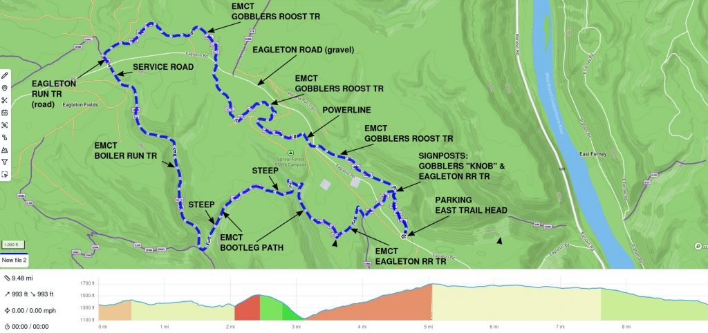
East Railroad Loop 1
Based on hiking some of the trails, we are proposing this 9.5 mile trek with 1000 feet of vertical (1000 down and 1000 up!) as the basic loop including the historic Eagleton Railroad route. Regretfully it’s too much for us to cover this on horseback anytime soon.
Eagleton RR Trail is fairly easy riding on the level. As it descends into the lovely hollow towards Bootleg Path it gets rockier with more roots and slope. It’s challenging, but not terrible. Bootleg Path (not explored) is probably the worst section. It appears to be pretty rocky and has steep slopes up and down, possibly near 20%. Boiler Run should all be fairly easy woods road, turning into a service road at the north end. Trail north of Eagleton Road is quite easy; the section where it wanders south of the road for a while is level but fairly rocky.
If you want to shorten the loop, returning via Eagleton Road trims it to 8.1 miles, with only 900 feet of vertical. The road is gravel and doesn’t usually see much traffic, but it is a road.
Note! Do not cut this loop short using Buckhorn Trail. It is signed as foot only, has some dangerous holes, passes right by a camp that is obviously used, and has a gate you probably can’t get around.
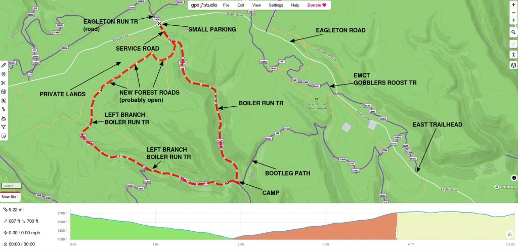
Boiler Loop
A possible 5.2 mile loop starts at Eagleton Road and Eagleton Run Trail (actually a road), where there is a small parking area (see photo below with bicyclist).
Boiler Run trail starts as a wide access road at a gate on Eagleton Road. After a short way the route turns off onto a camp access road which appears relatively easy riding down to Bootleg Path. It is two-track, grass and dirt with a few scattered rocks. It may narrow to single track at the bottom.
It appears new (2023-24) logging roads allow you to skirt private land along Eagleton Road and connect with Left Branch Boiler Run trail to form a loop. We haven’t made it all the way to the connecting point. These roads are quite wide, sunny, packed dirt and stone, relatively smooth, and fairly boring. Mountain bikers describe Left Branch trail itself as smooth single track with several steep grades. Campers in the area told us the trail is STEEP.
Although riding on this loop appears easy, it includes 700 feet of elevation change (700 down and 700 up). Even with gradual slopes that’s still a pretty good workout.
East Loop 1
This loop will not work! Buckhorn Trail is marked foot only and has a gate which is very hard to bypass with horses. Working on new loops.
This 6.5 mile sampler loop starts at the East trailhead and covers parts of Eagleton Railroad trail, Buckhorn Trail, and EMCT as far as Gobblers Roost trail, returning on (gravel) Eagleton Road and Holland Run trail before going back on EMCT. Trail names and limits are a little vague due to sketchy maps! We’re thinking this might be our first outing in the area. East Trailhead parking should be easy.

Central Loop 1
This loop will not work! Buckhorn Trail is marked foot only and has a gate which is very hard to bypass with horses. Working on new loops.
6.8 mile loop includes parts of Boiler Run trail, Bootleg Path, Buckhorn trail, EMCT (Gobblers Roost), and Eagleton Run trail.The direction shown has a steep climb on Bootleg Path in favor of a gradual descent on Boiler Run. There is limited parking at Eagleton Run Trail at Eagleton Road (photo below).

Getting There
Easily access the area from the east by taking PA 120 (Renovo road) 7 miles northwest from Lock Haven. Turn west on Eagleton road and it’s a 2.3 mile climb to the first parking area. Eagleton road is gravel, twisty and narrow, somewhat steep, and quite dusty, but the surface is fairly smooth. It’s narrow in this area, so if you encounter opposing traffic you may have to work to get by. Go slow!
Note that there is a right turn partway up Eagleton Road, poorly marked with a very confusing sign and small wooden post. If you don’t make the turn you will be on White Rock Lane… not Eagleton Road. Turning around could be interesting.
You can access the area from the west from Beech Creek by taking Monument-Orviston road and then Beech Creek Mountain road to Eagleton road. The latter two roads are gravel, so you will be going at least 9 miles on dusty and twisty roads, though they are relatively smooth and fairly wide.
Bugs
We were there 4th of July weekend after an extended rainy period. Bugs were bad. Really bad. As soon as we got out of the car, biting flies were coming after us.
In September, gnats were pretty irritating after just a little recent rain.
We will probably save Eagleton Mine Camp for fall riding, when weather is cooler.
Wildlife
So far we have seen a big flock of turkeys and lots of birds, but no deer or bear.
Local residents say there are lots of rattlesnakes in the region, which may make this a cool weather destination. Once the weather turns cool they say they disappear. We did see a big black snake and a tiny little snake on the trail, but nothing with rattles. Thankfully.
Facilities
None! Ha. There are no restrooms, no drinking water, not even a picnic table that we saw anywhere in the region. There are just trails and a few parking areas. And two hitching rails.
The nearest options are Lock Haven and Mill Hall, which have a considerable assortment of restaurants, fast food, fuel, etc.
Be aware that cell coverage in the area may be quite limited. Do not count on having service to navigate!
Camping
There are technically two “motorized camp sites” ![]() in the area which can be used for horse camping: Sproul Forest sites SS025 and SS026. One is along the side of the road, the other is a good ways back a rough access track (may be hard to access with a horse trailer!).
in the area which can be used for horse camping: Sproul Forest sites SS025 and SS026. One is along the side of the road, the other is a good ways back a rough access track (may be hard to access with a horse trailer!).
What makes these camp sites? The fact that Pennsylvania will charge you to stay there! There is nothing at either site, not even a picnic table. Obviously there are no restrooms or water, so if you don’t have an LQ trailer, you’re not invited. Pennsylvania’s support of outdoor recreation is often really sad.
Other Trail Users
Eagleton Mine Camp trail seems to primarily be used by mountain bikers, and some hikers. You should always expect to encounter bicyclists on the trails. We’ve never met anyone who took horses there, though postings online indicate a few people do. Most discussion online is not recent. We have seen a little manure at the east parking lot.

We saw a Forest Ranger stopped with a group of motorcycle/ATV users who weren’t looking too happy. None of the area trails are legally open to ATV use, but obviously that doesn’t stop people. Be alert for unexpected motorized users on both roads and trails.